Jalālābād geodata
Jalālābād (Nangarhar) is a seat of a first-order administrative division; located in Afghanistan in Asia/Kabul (GMT+4.5) time zone. With population of 200,331 people, there are 4 cities with bigger population in this country. Compared to other cities in Afghanistan, 55.9% of cities are located further ↑North; 88.1% of cities are located further ←West and 85.5% of cities have higher elevation than Jalālābād. Note1


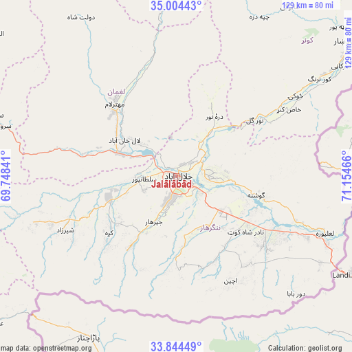
Jalālābād GPS coordinates[2]
34° 25' 35.292" North, 70° 27' 5.508" East
| Map corner | latitude | longitude |
|---|---|---|
| Upper-left | 35.00443°, | 69.74841° |
| Center: | 34.42647°, | 70.45153° |
| Lower-right: | 33.84449°, | 71.15466° |
| Map W x H: | 129×129 km | = 80.2×80.2mi |
| max Lat: | 38.4435° ⇑55.9% North |
| Jalālābād: | 34.42647° |
| min Lat: | ⇓44.1% South 30.15° |
| min Long | Jalālābād | max Long |
| 61.06667° | 70.45153° | 72.318° |
| W 88.1%⇐ | ⇒11.9% E |
Elevation
Elevation of Jalālābād is 575 m = 1886 ft, and this is 843.4 m = 2767 ft below average elevation for this country.
| Max E: |
3068 m = 10066 ft | 85.5% |
| Avg. | 1418.4 m = 4654 ft | |
| Jalālābād | 575 m = 1886 ft | |
Min E: |
254 m = 833 ft | 14.5% |
See also: Jalālābād elevation on elevation.city.
Geographical zone
Jalālābād is located in North temperate zone (between Tropic of Cancer and the Arctic Circle). Distance of this Northern Tropic circle is 1221.9 km =759.3 mi to South.| Distance of | km | miles | from Jalālābād |
|---|---|---|---|
| North Pole | 6179.2 | 3839.6 | to North |
| Arctic Circle | 3573.3 | 2220.3 | to North |
| Tropic Cancer | 1221.9 | 759.3 | to South |
| Equator | 3827.9 | 2378.5 | to South |


Nearby cities:
15 places around Jalālābād: (largest is in red/bold)
• Bāsawul
43.4 km =27 mi,  117°
117°
• Gōshtah
29.5 km =18.3 mi,  104°
104°
• Kai
41.2 km =25.6 mi,  143°
143°
• Kaz̲h̲ah
32.2 km =20 mi,  230°
230°
• Khafizan
17.2 km =10.7 mi,  205°
205°
• Kōṯowāl
36 km =22.4 mi,  178°
178°
• Markaz-e Woluswalī-ye Āchīn
40.9 km =25.4 mi, 144°
• Mehtar Lām
35.1 km =21.8 mi,  320°
320°
• Nūrgal
35.4 km =22 mi,  54°
54°
• Pachīr wa Āgām
29.8 km =18.5 mi, 212°
• Qal‘ah-ye Shāhī
27.9 km =17.3 mi,  27°
27°
• Qarghah’ī
23.8 km =14.8 mi,  306°
306°
• Sangar Sarāy
17.4 km =10.8 mi, 97°
• Sheywah
20.5 km =12.7 mi,  37°
37°
• Sulţānpūr-e ‘Ulyā
14.3 km =8.9 mi,  263°
263°
In other languages:
- In Spanish: Jalalabad
- In France: Jalalabad
- In German: Dschalalabad
- In Russian: Джелалабад
Sources, notices
• [Note1] Compared only with cities in Afghanistan existing in our database
• [Src1] Map data: © OpenStreetMap contributors (CC-BY-SA)
• [Src2] Other city data from geonames.org with taken over terms of usage.
• [Src3] Geographical zone / Annual Mean Temperature by Robert A. Rohde @ Wikipedia
