Qarghah’ī geodata
Qarghah’ī (Laghman) is a seat of a second-order administrative division; located in Afghanistan in Asia/Kabul (GMT+4.5) time zone. In our database, there are 93 cities with bigger population. Compared to other cities in Afghanistan, 53.4% of cities are located further ↑North; 85.2% of cities are located further ←West and 82.6% of cities have higher elevation than Qarghah’ī. Note1


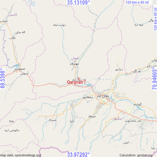
Qarghah’ī GPS coordinates[2]
34° 33' 14.472" North, 70° 14' 34.512" East
| Map corner | latitude | longitude |
|---|---|---|
| Upper-left | 35.13109°, | 69.5398° |
| Center: | 34.55402°, | 70.24292° |
| Lower-right: | 33.97292°, | 70.94605° |
| Map W x H: | 128.8×128.8 km | = 80×80mi |
| max Lat: | 38.4435° ⇑53.4% North |
| Qarghah’ī: | 34.55402° |
| min Lat: | ⇓46.6% South 30.15° |
| min Long | Qarghah’ī | max Long |
| 61.06667° | 70.24292° | 72.318° |
| W 85.2%⇐ | ⇒14.8% E |
Elevation
Elevation of Qarghah’ī is 659 m = 2162 ft, and this is 759.4 m = 2491 ft below average elevation for this country.
| Max E: |
3068 m = 10066 ft | 82.6% |
| Avg. | 1418.4 m = 4654 ft | |
| Qarghah’ī | 659 m = 2162 ft | |
Min E: |
254 m = 833 ft | 17.4% |
See also: Afghanistan elevation on elevation.city.
Geographical zone
Qarghah’ī is located in North temperate zone (between Tropic of Cancer and the Arctic Circle). Distance of this Northern Tropic circle is 1236.1 km =768.1 mi to South.| Distance of | km | miles | from Qarghah’ī |
|---|---|---|---|
| North Pole | 6165 | 3830.8 | to North |
| Arctic Circle | 3559.1 | 2211.5 | to North |
| Tropic Cancer | 1236.1 | 768.1 | to South |
| Equator | 3842 | 2387.3 | to South |


Nearby cities:
15 places around Qarghah’ī: (largest is in red/bold)
• Dowlat Shāh
46.8 km =29.1 mi,  340°
340°
• Gōshtah
52.4 km =32.6 mi,  114°
114°
• Jalālābād
23.8 km =14.8 mi,  126°
126°
• Kaz̲h̲ah
35.3 km =21.9 mi,  189°
189°
• Khafizan
32 km =19.9 mi,  158°
158°
• Mehtar Lām
13.4 km =8.3 mi,  346°
346°
• Māmā Khēl
41.1 km =25.5 mi,  213°
213°
• Nūrgal
48.2 km =30 mi,  82°
82°
• Pachīr wa Āgām
39.5 km =24.5 mi,  175°
175°
• Qal‘ah-ye Shāhī
33.6 km =20.9 mi,  71°
71°
• Sangar Sarāy
39.8 km =24.7 mi, 114°
• Sarōbī
44.4 km =27.6 mi,  275°
275°
• Sheywah
31.7 km =19.7 mi,  86°
86°
• Sulţānpūr-e ‘Ulyā
16.5 km =10.3 mi, 162°
• Wuluswālī ‘Alīngār
33 km =20.5 mi,  18°
18°
Sources, notices
• [Note1] Compared only with cities in Afghanistan existing in our database
• [Src1] Map data: © OpenStreetMap contributors (CC-BY-SA)
• [Src2] Other city data from geonames.org with taken over terms of usage.
• [Src3] Geographical zone / Annual Mean Temperature by Robert A. Rohde @ Wikipedia
