Banū geodata
Banū (Baghlan) is a seat of a second-order administrative division; located in Afghanistan in Asia/Kabul (GMT+4.5) time zone. In our database, there are 93 cities with bigger population. Compared to other cities in Afghanistan, 71.1% of cities are located further ↓South; 67.5% of cities are located further ←West and 55% of cities have lower elevation than Banū. Note1


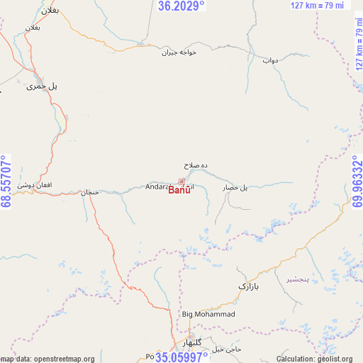
Banū GPS coordinates[2]
35° 38' 0.528" North, 69° 15' 36.684" East
| Map corner | latitude | longitude |
|---|---|---|
| Upper-left | 36.2029°, | 68.55707° |
| Center: | 35.63348°, | 69.26019° |
| Lower-right: | 35.05997°, | 69.96332° |
| Map W x H: | 127.1×127.1 km | = 79×79mi |
| max Lat: | 38.4435° ⇑28.9% North |
| Banū: | 35.63348° |
| min Lat: | ⇓71.1% South 30.15° |
| min Long | Banū | max Long |
| 61.06667° | 69.26019° | 72.318° |
| W 67.5%⇐ | ⇒32.5% E |
Elevation
Elevation of Banū is 1510 m = 4954 ft, and this is 91.6 m = 301 ft above average elevation for this country.
| Max E: |
3068 m = 10066 ft | 45% |
| Banū | 1510 m 4954 ft | |
| Avg. | 1418.4 m = 4654 ft | |
Min E: |
254 m = 833 ft | 55% |
See also: Afghanistan elevation on elevation.city.
Geographical zone
Banū is located in North temperate zone (between Tropic of Cancer and the Arctic Circle). Distance of this Northern Tropic circle is 1356.2 km =842.7 mi to South.| Distance of | km | miles | from Banū |
|---|---|---|---|
| North Pole | 6045 | 3756.2 | to North |
| Arctic Circle | 3439.1 | 2137 | to North |
| Tropic Cancer | 1356.2 | 842.7 | to South |
| Equator | 3962.1 | 2461.9 | to South |


Nearby cities:
15 places around Banū: (largest is in red/bold)
• Bāgh-e Maīdān
46 km =28.6 mi,  185°
185°
• Bāzārak
42.5 km =26.4 mi,  147°
147°
• Būrkah
66.2 km =41.1 mi,  351°
351°
• Deh-e Şalāḩ
8 km =5 mi,  38°
38°
• Dōshī
52.1 km =32.4 mi,  267°
267°
• Ibrāhīm Khān
64.5 km =40.1 mi,  180°
180°
• Jabal os Saraj
57.3 km =35.6 mi, 182°
• Khinj
48.6 km =30.2 mi,  117°
117°
• Khinjān
32.8 km =20.4 mi,  261°
261°
• Kirāmān
53.4 km =33.2 mi,  134°
134°
• Nahrīn
49.3 km =30.6 mi, 346°
• Pul-e Khumrī
60.1 km =37.3 mi,  305°
305°
• Pul-e Ḩişār
19.2 km =11.9 mi,  95°
95°
• Ḩājī Khēl
60.4 km =37.5 mi,  164°
164°
• ’Unābah
45.8 km =28.5 mi,  166°
166°
Sources, notices
• [Note1] Compared only with cities in Afghanistan existing in our database
• [Src1] Map data: © OpenStreetMap contributors (CC-BY-SA)
• [Src2] Other city data from geonames.org with taken over terms of usage.
• [Src3] Geographical zone / Annual Mean Temperature by Robert A. Rohde @ Wikipedia
