Bāzārak geodata
Bāzārak (Panjshir) is a seat of a first-order administrative division; located in Afghanistan in Asia/Kabul (GMT+4.5) time zone. With population of 65,000 people, there are 13 cities with bigger population in this country. Compared to other cities in Afghanistan, 66.2% of cities are located further ↓South; 74% of cities are located further ←West and 72% of cities have lower elevation than Bāzārak. Note1


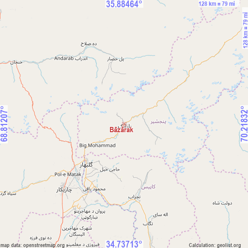
Bāzārak GPS coordinates[2]
35° 18' 46.512" North, 69° 30' 54.684" East
| Map corner | latitude | longitude |
|---|---|---|
| Upper-left | 35.88464°, | 68.81207° |
| Center: | 35.31292°, | 69.51519° |
| Lower-right: | 34.73713°, | 70.21832° |
| Map W x H: | 127.6×127.6 km | = 79.3×79.3mi |
| max Lat: | 38.4435° ⇑33.8% North |
| Bāzārak: | 35.31292° |
| min Lat: | ⇓66.2% South 30.15° |
| min Long | Bāzārak | max Long |
| 61.06667° | 69.51519° | 72.318° |
| W 74%⇐ | ⇒26% E |
Elevation
Elevation of Bāzārak is 1965 m = 6447 ft, and this is 546.6 m = 1793 ft above average elevation for this country.
| Max E: |
3068 m = 10066 ft | 28% |
| Bāzārak | 1965 m 6447 ft | |
| Avg. | 1418.4 m = 4654 ft | |
Min E: |
254 m = 833 ft | 72% |
See also: Bāzārak elevation on elevation.city.
Geographical zone
Bāzārak is located in North temperate zone (between Tropic of Cancer and the Arctic Circle). Distance of this Northern Tropic circle is 1320.5 km =820.5 mi to South.| Distance of | km | miles | from Bāzārak |
|---|---|---|---|
| North Pole | 6080.6 | 3778.3 | to North |
| Arctic Circle | 3474.7 | 2159.1 | to North |
| Tropic Cancer | 1320.5 | 820.5 | to South |
| Equator | 3926.4 | 2439.8 | to South |


Nearby cities:
15 places around Bāzārak: (largest is in red/bold)
• Alah Sāy
49.9 km =31 mi,  158°
158°
• Banū
42.5 km =26.4 mi,  327°
327°
• Bāgh-e Maīdān
29.2 km =18.1 mi,  249°
249°
• Charikar
45.7 km =28.4 mi,  223°
223°
• Deh-e Şalāḩ
45.7 km =28.4 mi,  336°
336°
• Ghulām ‘Alī
48 km =29.8 mi,  212°
212°
• Ibrāhīm Khān
37.2 km =23.1 mi, 219°
• Jabal os Saraj
33.2 km =20.6 mi,  229°
229°
• Khinj
23.7 km =14.7 mi,  57°
57°
• Kirāmān
15.2 km =9.4 mi,  96°
96°
• Pul-e Ḩişār
34.1 km =21.2 mi,  353°
353°
• Shērwānī-ye Bālā
34 km =21.1 mi,  167°
167°
• Sidqābād
35.5 km =22.1 mi,  204°
204°
• Ḩājī Khēl
23.8 km =14.8 mi, 198°
• ’Unābah
15.4 km =9.6 mi, 234°
Sources, notices
• [Note1] Compared only with cities in Afghanistan existing in our database
• [Src1] Map data: © OpenStreetMap contributors (CC-BY-SA)
• [Src2] Other city data from geonames.org with taken over terms of usage.
• [Src3] Geographical zone / Annual Mean Temperature by Robert A. Rohde @ Wikipedia
