Bāgh-e Maīdān geodata
Bāgh-e Maīdān (Parwan) is a seat of a second-order administrative division; located in Afghanistan in Asia/Kabul (GMT+4.5) time zone. In our database, there are 93 cities with bigger population. Compared to other cities in Afghanistan, 64.6% of cities are located further ↓South; 65.3% of cities are located further ←West and 73.3% of cities have lower elevation than Bāgh-e Maīdān. Note1


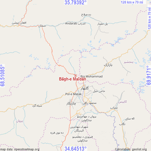
Bāgh-e Maīdān GPS coordinates[2]
35° 13' 17.616" North, 69° 12' 50.292" East
| Map corner | latitude | longitude |
|---|---|---|
| Upper-left | 35.79392°, | 68.51085° |
| Center: | 35.22156°, | 69.21397° |
| Lower-right: | 34.64513°, | 69.9171° |
| Map W x H: | 127.7×127.7 km | = 79.3×79.3mi |
| max Lat: | 38.4435° ⇑35.4% North |
| Bāgh-e Maīdān: | 35.22156° |
| min Lat: | ⇓64.6% South 30.15° |
| min Long | Bāgh-e Maīdā | max Long |
| 61.06667° | 69.21397° | 72.318° |
| W 65.3%⇐ | ⇒34.7% E |
Elevation
Elevation of Bāgh-e Maīdān is 1988 m = 6522 ft, and this is 569.6 m = 1869 ft above average elevation for this country.
| Max E: |
3068 m = 10066 ft | 26.7% |
| Bāgh-e Maīdān | 1988 m 6522 ft | |
| Avg. | 1418.4 m = 4654 ft | |
Min E: |
254 m = 833 ft | 73.3% |
See also: Afghanistan elevation on elevation.city.
Geographical zone
Bāgh-e Maīdān is located in North temperate zone (between Tropic of Cancer and the Arctic Circle). Distance of this Northern Tropic circle is 1310.4 km =814.2 mi to South.| Distance of | km | miles | from Bāgh-e Maīdān |
|---|---|---|---|
| North Pole | 6090.8 | 3784.6 | to North |
| Arctic Circle | 3484.9 | 2165.4 | to North |
| Tropic Cancer | 1310.4 | 814.2 | to South |
| Equator | 3916.3 | 2433.5 | to South |


Nearby cities:
15 places around Bāgh-e Maīdān: (largest is in red/bold)
• Banū
46 km =28.6 mi,  5°
5°
• Bāzārak
29.2 km =18.1 mi,  69°
69°
• Charikar
23.4 km =14.5 mi,  189°
189°
• Ghulām ‘Alī
30.1 km =18.7 mi,  177°
177°
• Ibrāhīm Khān
19.1 km =11.9 mi,  168°
168°
• Istālif
45 km =28 mi,  196°
196°
• Jabal os Saraj
11.7 km =7.3 mi, 169°
• Kirāmān
43.3 km =26.9 mi,  78°
78°
• Qarah Bāgh Bāzār
41.2 km =25.6 mi, 185°
• Qāshqāl
27.6 km =17.1 mi,  222°
222°
• Shērwānī-ye Bālā
41.9 km =26 mi,  123°
123°
• Sidqābād
25.4 km =15.8 mi,  150°
150°
• Siyāhgird
40.5 km =25.2 mi,  233°
233°
• Ḩājī Khēl
23.5 km =14.6 mi, 122°
• ’Unābah
14.9 km =9.3 mi,  85°
85°
Sources, notices
• [Note1] Compared only with cities in Afghanistan existing in our database
• [Src1] Map data: © OpenStreetMap contributors (CC-BY-SA)
• [Src2] Other city data from geonames.org with taken over terms of usage.
• [Src3] Geographical zone / Annual Mean Temperature by Robert A. Rohde @ Wikipedia
