Dōshī geodata
Dōshī (Baghlan) is a seat of a second-order administrative division; located in Afghanistan in Asia/Kabul (GMT+4.5) time zone. In our database, there are 93 cities with bigger population. Compared to other cities in Afghanistan, 70.1% of cities are located further ↓South; 52.1% of cities are located further ←West and 74.6% of cities have higher elevation than Dōshī. Note1


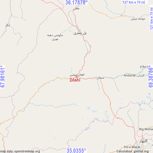
Dōshī GPS coordinates[2]
35° 36' 33.048" North, 68° 41' 5.028" East
| Map corner | latitude | longitude |
|---|---|---|
| Upper-left | 36.17878°, | 67.98161° |
| Center: | 35.60918°, | 68.68473° |
| Lower-right: | 35.0355°, | 69.38786° |
| Map W x H: | 127.1×127.1 km | = 79×79mi |
| max Lat: | 38.4435° ⇑29.9% North |
| Dōshī: | 35.60918° |
| min Lat: | ⇓70.1% South 30.15° |
| min Long | Dōshī | max Long |
| 61.06667° | 68.68473° | 72.318° |
| W 52.1%⇐ | ⇒47.9% E |
Elevation
Elevation of Dōshī is 836 m = 2743 ft, and this is 582.4 m = 1911 ft below average elevation for this country.
| Max E: |
3068 m = 10066 ft | 74.6% |
| Avg. | 1418.4 m = 4654 ft | |
| Dōshī | 836 m = 2743 ft | |
Min E: |
254 m = 833 ft | 25.4% |
See also: Afghanistan elevation on elevation.city.
Geographical zone
Dōshī is located in North temperate zone (between Tropic of Cancer and the Arctic Circle). Distance of this Northern Tropic circle is 1353.5 km =841 mi to South.| Distance of | km | miles | from Dōshī |
|---|---|---|---|
| North Pole | 6047.7 | 3757.9 | to North |
| Arctic Circle | 3441.8 | 2138.6 | to North |
| Tropic Cancer | 1353.5 | 841 | to South |
| Equator | 3959.4 | 2460.3 | to South |


Nearby cities:
15 places around Dōshī: (largest is in red/bold)
• Baghlān
58 km =36 mi,  2°
2°
• Banū
52.1 km =32.4 mi,  87°
87°
• Bāgh-e Maīdān
64.5 km =40.1 mi,  131°
131°
• Bāzār-e Tālah
48.3 km =30 mi,  239°
239°
• Deh-e Şalāḩ
57.7 km =35.9 mi,  81°
81°
• Jabal os Saraj
74.1 km =46 mi,  137°
137°
• Khinjān
19.7 km =12.2 mi,  96°
96°
• Langar
71.5 km =44.4 mi,  306°
306°
• Nahrīn
64.8 km =40.3 mi,  38°
38°
• Pul-e Khumrī
37.4 km =23.2 mi, 4°
• Pul-e Ḩişār
71.1 km =44.2 mi, 89°
• Qāshqāl
69.7 km =43.3 mi,  155°
155°
• Siyāhgird
68.9 km =42.8 mi,  166°
166°
• Ḩukūmatī Dahanah-ye Ghōrī
37.5 km =23.3 mi,  331°
331°
• ’Unābah
75.4 km =46.9 mi,  123°
123°
Sources, notices
• [Note1] Compared only with cities in Afghanistan existing in our database
• [Src1] Map data: © OpenStreetMap contributors (CC-BY-SA)
• [Src2] Other city data from geonames.org with taken over terms of usage.
• [Src3] Geographical zone / Annual Mean Temperature by Robert A. Rohde @ Wikipedia
