Lekbibaj geodata
Lekbibaj (Kukës) is a seat of a third-order administrative division; located in Albania in Europe/Tirane (GMT+2) time zone. In our database, there are 71 cities with bigger population. Compared to other cities in Albania, 97.7% of cities are located further ↓South; 54.4% of cities are located further →East and 53.5% of cities have lower elevation than Lekbibaj. Note1


Lekbibaj GPS coordinates[2]
42° 17' 40.992" North, 19° 55' 54.012" East
| Map corner | latitude | longitude |
|---|---|---|
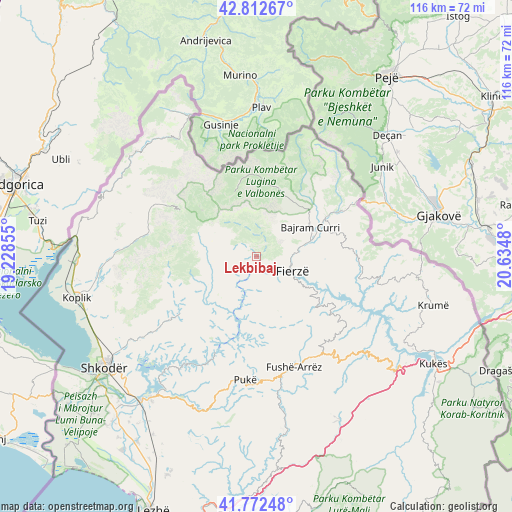
| Upper-left | 42.81267°, | 19.22855° |
| Center: | 42.29472°, | 19.93167° |
| Lower-right: | 41.77248°, | 20.6348° |
| Map W x H: | 115.7×115.7 km | = 71.9×71.9mi |
| max Lat: | 42.45139° ⇑2.3% North |
| Lekbibaj: | 42.29472° |
| min Lat: | ⇓97.7% South 39.65889° |
| min Long | Lekbibaj | max Long |
| 19.40556° | 19.93167° | 20.99° |
| W 45.6%⇐ | ⇒54.4% E |
Elevation
Elevation of Lekbibaj is 318 m = 1043 ft, and this is 56.6 m = 186 ft below average elevation for this country.
| Max E: |
1352 m = 4436 ft | 46.5% |
| Avg. | 374.6 m = 1229 ft | |
| Lekbibaj | 318 m = 1043 ft | |
Min E: |
-2 m = -7 ft | 53.5% |
See also: Albania elevation on elevation.city.
Geographical zone
Lekbibaj is located in North temperate zone (between Tropic of Cancer and the Arctic Circle). Distance of this Northern Tropic circle is 2096.8 km =1302.9 mi to South.| Distance of | km | miles | from Lekbibaj |
|---|---|---|---|
| North Pole | 5304.3 | 3295.9 | to North |
| Arctic Circle | 2698.4 | 1676.7 | to North |
| Tropic Cancer | 2096.8 | 1302.9 | to South |
| Equator | 4702.7 | 2922.1 | to South |


Nearby cities:
15 places around Lekbibaj: (largest is in red/bold)
• Bajram Curri
13.8 km =8.6 mi,  59°
59°
• Blerim
26.1 km =16.2 mi,  124°
124°
• Bujan
12.4 km =7.7 mi,  73°
73°
• Bushat
19.7 km =12.2 mi,  187°
187°
• Bytyç
22.4 km =13.9 mi,  85°
85°
• Fierzë
8 km =5 mi, 118°
• Fushë-Arrëz
26.8 km =16.7 mi,  164°
164°
• Iballë
13.3 km =8.3 mi,  153°
153°
• Llugaj
15.4 km =9.6 mi, 70°
• Nicaj-Shalë
10.4 km =6.5 mi,  272°
272°
• Nicaj-Shosh
15.3 km =9.5 mi,  248°
248°
• Qafëmal
25.9 km =16.1 mi, 149°
• Qelëz
23 km =14.3 mi, 187°
• Rrapë
28 km =17.4 mi,  173°
173°
• Valbonë
17.7 km =11 mi,  349°
349°
Sources, notices
• [Note1] Compared only with cities in Albania existing in our database
• [Src1] Map data: © OpenStreetMap contributors (CC-BY-SA)
• [Src2] Other city data from geonames.org with taken over terms of usage.
• [Src3] Geographical zone / Annual Mean Temperature by Robert A. Rohde @ Wikipedia
