Fierzë geodata
Fierzë (Shkodër) is a seat of a third-order administrative division; located in Albania in Europe/Tirane (GMT+2) time zone. In our database, there are 71 cities with bigger population. Compared to other cities in Albania, 97.5% of cities are located further ↓South; 53.2% of cities are located further ←West and 51.8% of cities have lower elevation than Fierzë. Note1


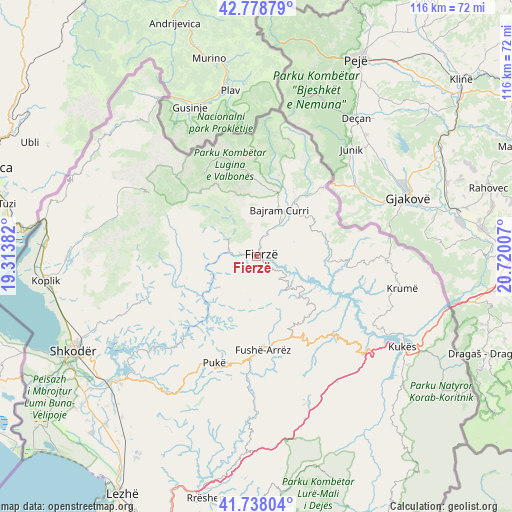
Fierzë GPS coordinates[2]
42° 15' 38.016" North, 20° 1' 0.984" East
| Map corner | latitude | longitude |
|---|---|---|
| Upper-left | 42.77879°, | 19.31382° |
| Center: | 42.26056°, | 20.01694° |
| Lower-right: | 41.73804°, | 20.72007° |
| Map W x H: | 115.7×115.7 km | = 71.9×71.9mi |
| max Lat: | 42.45139° ⇑2.5% North |
| Fierzë: | 42.26056° |
| min Lat: | ⇓97.5% South 39.65889° |
| min Long | Fierzë | max Long |
| 19.40556° | 20.01694° | 20.99° |
| W 53.2%⇐ | ⇒46.8% E |
Elevation
Elevation of Fierzë is 303 m = 994 ft, and this is 71.6 m = 235 ft below average elevation for this country.
| Max E: |
1352 m = 4436 ft | 48.2% |
| Avg. | 374.6 m = 1229 ft | |
| Fierzë | 303 m = 994 ft | |
Min E: |
-2 m = -7 ft | 51.8% |
See also: Albania elevation on elevation.city.
Geographical zone
Fierzë is located in North temperate zone (between Tropic of Cancer and the Arctic Circle). Distance of this Northern Tropic circle is 2093 km =1300.5 mi to South.| Distance of | km | miles | from Fierzë |
|---|---|---|---|
| North Pole | 5308.1 | 3298.3 | to North |
| Arctic Circle | 2702.2 | 1679.1 | to North |
| Tropic Cancer | 2093 | 1300.5 | to South |
| Equator | 4698.9 | 2919.8 | to South |


Nearby cities:
15 places around Fierzë: (largest is in red/bold)
• Bajram Curri
11.8 km =7.3 mi,  24°
24°
• Blerim
18.2 km =11.3 mi,  127°
127°
• Bujan
8.8 km =5.5 mi,  33°
33°
• Bushat
18.4 km =11.4 mi,  211°
211°
• Bytyç
16.2 km =10.1 mi,  70°
70°
• Fushë-Arrëz
22.1 km =13.7 mi,  180°
180°
• Iballë
8.2 km =5.1 mi,  188°
188°
• Lekbibaj
8 km =5 mi,  298°
298°
• Llugaj
11.7 km =7.3 mi,  39°
39°
• Nicaj-Shalë
18 km =11.2 mi,  283°
283°
• Nicaj-Shosh
21.4 km =13.3 mi,  265°
265°
• Qafëmal
19.6 km =12.2 mi,  161°
161°
• Qelëz
21.5 km =13.4 mi, 207°
• Rrapë
24.3 km =15.1 mi, 189°
• Valbonë
23.6 km =14.7 mi,  334°
334°
Sources, notices
• [Note1] Compared only with cities in Albania existing in our database
• [Src1] Map data: © OpenStreetMap contributors (CC-BY-SA)
• [Src2] Other city data from geonames.org with taken over terms of usage.
• [Src3] Geographical zone / Annual Mean Temperature by Robert A. Rohde @ Wikipedia
