Iballë geodata
Iballë (Shkodër) is a seat of a third-order administrative division; located in Albania in Europe/Tirane (GMT+2) time zone. In our database, there are 71 cities with bigger population. Compared to other cities in Albania, 96.1% of cities are located further ↓South; 50.7% of cities are located further ←West and 82% of cities have lower elevation than Iballë. Note1


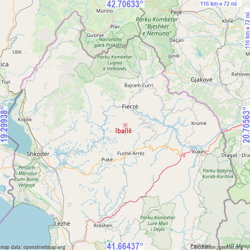
Iballë GPS coordinates[2]
42° 11' 15" North, 20° 0' 9" East
| Map corner | latitude | longitude |
|---|---|---|
| Upper-left | 42.70633°, | 19.29938° |
| Center: | 42.1875°, | 20.0025° |
| Lower-right: | 41.66437°, | 20.70563° |
| Map W x H: | 115.9×115.9 km | = 72×72mi |
| max Lat: | 42.45139° ⇑3.9% North |
| Iballë: | 42.1875° |
| min Lat: | ⇓96.1% South 39.65889° |
| min Long | Iballë | max Long |
| 19.40556° | 20.0025° | 20.99° |
| W 50.7%⇐ | ⇒49.3% E |
Elevation
Elevation of Iballë is 765 m = 2510 ft, and this is 390.4 m = 1281 ft above average elevation for this country.
| Max E: |
1352 m = 4436 ft | 18% |
| Iballë | 765 m 2510 ft | |
| Avg. | 374.6 m = 1229 ft | |
Min E: |
-2 m = -7 ft | 82% |
See also: Albania elevation on elevation.city.
Geographical zone
Iballë is located in North temperate zone (between Tropic of Cancer and the Arctic Circle). Distance of this Northern Tropic circle is 2084.9 km =1295.5 mi to South.| Distance of | km | miles | from Iballë |
|---|---|---|---|
| North Pole | 5316.3 | 3303.4 | to North |
| Arctic Circle | 2710.4 | 1684.2 | to North |
| Tropic Cancer | 2084.9 | 1295.5 | to South |
| Equator | 4690.8 | 2914.7 | to South |


Nearby cities:
15 places around Iballë: (largest is in red/bold)
• Bajram Curri
19.8 km =12.3 mi,  17°
17°
• Blerim
15.9 km =9.9 mi,  100°
100°
• Bujan
16.6 km =10.3 mi, 21°
• Bushat
11.4 km =7.1 mi,  228°
228°
• Fierzë
8.2 km =5.1 mi,  8°
8°
• Fushë-Arrëz
14 km =8.7 mi,  175°
175°
• Lekbibaj
13.3 km =8.3 mi,  333°
333°
• Llugaj
19.2 km =11.9 mi,  27°
27°
• Nicaj-Shalë
20.5 km =12.7 mi,  307°
307°
• Nicaj-Shosh
21.1 km =13.1 mi,  287°
287°
• Pukë
18 km =11.2 mi,  208°
208°
• Qafëmal
12.7 km =7.9 mi,  145°
145°
• Qelëz
14 km =8.7 mi,  219°
219°
• Qerret
20.2 km =12.6 mi, 222°
• Rrapë
16.1 km =10 mi,  189°
189°
Sources, notices
• [Note1] Compared only with cities in Albania existing in our database
• [Src1] Map data: © OpenStreetMap contributors (CC-BY-SA)
• [Src2] Other city data from geonames.org with taken over terms of usage.
• [Src3] Geographical zone / Annual Mean Temperature by Robert A. Rohde @ Wikipedia
