Rrapë geodata
Rrapë (Shkodër) is a seat of a third-order administrative division; located in Albania in Europe/Tirane (GMT+2) time zone. In our database, there are 71 cities with bigger population. Compared to other cities in Albania, 91% of cities are located further ↓South; 51.5% of cities are located further →East and 83.7% of cities have lower elevation than Rrapë. Note1


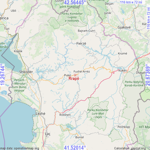
Rrapë GPS coordinates[2]
42° 2' 39.984" North, 19° 58' 14.016" East
| Map corner | latitude | longitude |
|---|---|---|
| Upper-left | 42.56445°, | 19.26744° |
| Center: | 42.04444°, | 19.97056° |
| Lower-right: | 41.52014°, | 20.67369° |
| Map W x H: | 116.1×116.1 km | = 72.1×72.1mi |
| max Lat: | 42.45139° ⇑9% North |
| Rrapë: | 42.04444° |
| min Lat: | ⇓91% South 39.65889° |
| min Long | Rrapë | max Long |
| 19.40556° | 19.97056° | 20.99° |
| W 48.5%⇐ | ⇒51.5% E |
Elevation
Elevation of Rrapë is 792 m = 2598 ft, and this is 417.4 m = 1369 ft above average elevation for this country.
| Max E: |
1352 m = 4436 ft | 16.3% |
| Rrapë | 792 m 2598 ft | |
| Avg. | 374.6 m = 1229 ft | |
Min E: |
-2 m = -7 ft | 83.7% |
See also: Albania elevation on elevation.city.
Geographical zone
Rrapë is located in North temperate zone (between Tropic of Cancer and the Arctic Circle). Distance of this Northern Tropic circle is 2069 km =1285.6 mi to South.| Distance of | km | miles | from Rrapë |
|---|---|---|---|
| North Pole | 5332.2 | 3313.3 | to North |
| Arctic Circle | 2726.3 | 1694 | to North |
| Tropic Cancer | 2069 | 1285.6 | to South |
| Equator | 4674.9 | 2904.8 | to South |


Nearby cities:
15 places around Rrapë: (largest is in red/bold)
• Blerim
22.4 km =13.9 mi,  54°
54°
• Blinisht
20.5 km =12.7 mi,  173°
173°
• Bushat
10.2 km =6.3 mi,  324°
324°
• Fierzë
24.3 km =15.1 mi,  9°
9°
• Fushë-Arrëz
4.3 km =2.7 mi,  62°
62°
• Gjegjan
12.3 km =7.6 mi,  164°
164°
• Iballë
16.1 km =10 mi, 9°
• Kaçinar
17.8 km =11.1 mi,  199°
199°
• Pukë
5.8 km =3.6 mi,  270°
270°
• Qafëmal
11.3 km =7 mi, 61°
• Qelëz
8 km =5 mi,  308°
308°
• Qerret
11.1 km =6.9 mi, 274°
• Shëngjin
22.3 km =13.9 mi,  126°
126°
• Shënmëri
23.1 km =14.4 mi,  73°
73°
• Ungrej
23.8 km =14.8 mi,  217°
217°
Sources, notices
• [Note1] Compared only with cities in Albania existing in our database
• [Src1] Map data: © OpenStreetMap contributors (CC-BY-SA)
• [Src2] Other city data from geonames.org with taken over terms of usage.
• [Src3] Geographical zone / Annual Mean Temperature by Robert A. Rohde @ Wikipedia
