Tsovak geodata
Tsovak (Gegharkunik) is a populated place; located in Armenia in Asia/Yerevan (GMT+4) time zone. With population of 2,531 people, there are 112 cities with bigger population in this country. Compared to other cities in Armenia, 53.2% of cities are located further ↑North; 93.3% of cities are located further ←West and 87.6% of cities have lower elevation than Tsovak. Note1


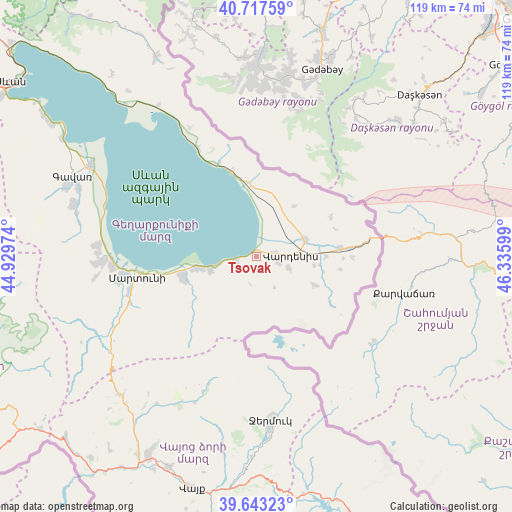
Tsovak GPS coordinates[2]
40° 10' 57.144" North, 45° 37' 58.296" East
| Map corner | latitude | longitude |
|---|---|---|
| Upper-left | 40.71759°, | 44.92974° |
| Center: | 40.18254°, | 45.63286° |
| Lower-right: | 39.64323°, | 46.33599° |
| Map W x H: | 119.5×119.5 km | = 74.3×74.3mi |
| max Lat: | 41.24358° ⇑53.2% North |
| Tsovak: | 40.18254° |
| min Lat: | ⇓46.8% South 38.90292° |
| min Long | Tsovak | max Long |
| 43.74722° | 45.63286° | 46.5446° |
| W 93.3%⇐ | ⇒6.7% E |
Elevation
Elevation of Tsovak is 1923 m = 6309 ft, and this is 621.5 m = 2039 ft above average elevation for this country.
| Max E: |
2169 m = 7116 ft | 12.4% |
| Tsovak | 1923 m 6309 ft | |
| Avg. | 1301.5 m = 4270 ft | |
Min E: |
440 m = 1444 ft | 87.6% |
See also: Armenia elevation on elevation.city.
Geographical zone
Tsovak is located in North temperate zone (between Tropic of Cancer and the Arctic Circle). Distance of this Northern Tropic circle is 1862 km =1157 mi to South.| Distance of | km | miles | from Tsovak |
|---|---|---|---|
| North Pole | 5539.2 | 3441.9 | to North |
| Arctic Circle | 2933.3 | 1822.7 | to North |
| Tropic Cancer | 1862 | 1157 | to South |
| Equator | 4467.9 | 2776.2 | to South |


Nearby cities:
15 places around Tsovak: (largest is in red/bold)
• Akunk’
8.3 km =5.2 mi,  108°
108°
• Astghadzor
24.5 km =15.2 mi,  254°
254°
• Geghamasar
14.8 km =9.2 mi,  15°
15°
• Karanlukh
30.4 km =18.9 mi, 253°
• Karchaghbyur
4.9 km =3 mi, 253°
• Lichk’
33.9 km =21.1 mi,  265°
265°
• Madina
34.2 km =21.3 mi, 249°
• Martuni
28.2 km =17.5 mi,  260°
260°
• Mets Masrik
11.9 km =7.4 mi,  69°
69°
• Nerk’in Getashen
31.1 km =19.3 mi, 261°
• Tsovinar
14.2 km =8.8 mi, 259°
• Vaghashen
26.2 km =16.3 mi, 258°
• Vardenik
17 km =10.6 mi, 251°
• Vardenis
8.3 km =5.2 mi,  89°
89°
• Verin Getashen
32.8 km =20.4 mi, 259°
Sources, notices
• [Note1] Compared only with cities in Armenia existing in our database
• [Src1] Map data: © OpenStreetMap contributors (CC-BY-SA)
• [Src2] Other city data from geonames.org with taken over terms of usage.
• [Src3] Geographical zone / Annual Mean Temperature by Robert A. Rohde @ Wikipedia
