Geghamasar geodata
Geghamasar (Gegharkunik) is a populated place; located in Armenia in Asia/Yerevan (GMT+4) time zone. With population of 1,060 people, there are 293 cities with bigger population in this country. Compared to other cities in Armenia, 59.6% of cities are located further ↓South; 93.9% of cities are located further ←West and 97.8% of cities have lower elevation than Geghamasar. Note1


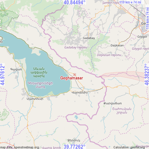
Geghamasar GPS coordinates[2]
40° 18' 39.276" North, 45° 40' 45.264" East
| Map corner | latitude | longitude |
|---|---|---|
| Upper-left | 40.84494°, | 44.97612° |
| Center: | 40.31091°, | 45.67924° |
| Lower-right: | 39.77262°, | 46.38237° |
| Map W x H: | 119.2×119.2 km | = 74.1×74.1mi |
| max Lat: | 41.24358° ⇑40.4% North |
| Geghamasar: | 40.31091° |
| min Lat: | ⇓59.6% South 38.90292° |
| min Long | Geghamasar | max Long |
| 43.74722° | 45.67924° | 46.5446° |
| W 93.9%⇐ | ⇒6.1% E |
Elevation
Elevation of Geghamasar is 2047 m = 6716 ft, and this is 745.5 m = 2446 ft above average elevation for this country.
| Max E: |
2169 m = 7116 ft | 2.2% |
| Geghamasar | 2047 m 6716 ft | |
| Avg. | 1301.5 m = 4270 ft | |
Min E: |
440 m = 1444 ft | 97.8% |
See also: Armenia elevation on elevation.city.
Geographical zone
Geghamasar is located in North temperate zone (between Tropic of Cancer and the Arctic Circle). Distance of this Northern Tropic circle is 1876.2 km =1165.8 mi to South.| Distance of | km | miles | from Geghamasar |
|---|---|---|---|
| North Pole | 5524.9 | 3433 | to North |
| Arctic Circle | 2919 | 1813.8 | to North |
| Tropic Cancer | 1876.2 | 1165.8 | to South |
| Equator | 4482.2 | 2785.1 | to South |


Nearby cities:
15 places around Geghamasar: (largest is in red/bold)
• Akunk’
17.4 km =10.8 mi,  166°
166°
• Astghadzor
34.6 km =21.5 mi,  232°
232°
• Karanlukh
40.3 km =25 mi,  235°
235°
• Karchaghbyur
17.8 km =11.1 mi,  208°
208°
• Lichk’
41.3 km =25.7 mi,  245°
245°
• Martuni
37 km =23 mi, 238°
• Mets Masrik
12.4 km =7.7 mi,  144°
144°
• Nerk’in Getashen
39.4 km =24.5 mi, 241°
• Tsovak
14.8 km =9.2 mi,  195°
195°
• Tsovinar
24.6 km =15.3 mi, 226°
• Vaghashen
35.4 km =22 mi, 236°
• Vahan
37.9 km =23.5 mi,  320°
320°
• Vardenik
28.1 km =17.5 mi, 225°
• Vardenis
14.8 km =9.2 mi,  162°
162°
• Verin Getashen
41.4 km =25.7 mi, 241°
Sources, notices
• [Note1] Compared only with cities in Armenia existing in our database
• [Src1] Map data: © OpenStreetMap contributors (CC-BY-SA)
• [Src2] Other city data from geonames.org with taken over terms of usage.
• [Src3] Geographical zone / Annual Mean Temperature by Robert A. Rohde @ Wikipedia
