Mets Masrik geodata
Mets Masrik (Gegharkunik) is a populated place; located in Armenia in Asia/Yerevan (GMT+4) time zone. With population of 2,570 people, there are 111 cities with bigger population in this country. Compared to other cities in Armenia, 50.6% of cities are located further ↓South; 95.2% of cities are located further ←West and 91.1% of cities have lower elevation than Mets Masrik. Note1


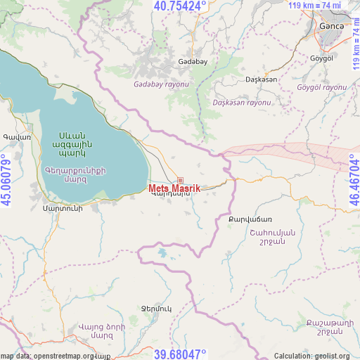
Mets Masrik GPS coordinates[2]
40° 13' 10.128" North, 45° 45' 50.076" East
| Map corner | latitude | longitude |
|---|---|---|
| Upper-left | 40.75424°, | 45.06079° |
| Center: | 40.21948°, | 45.76391° |
| Lower-right: | 39.68047°, | 46.46704° |
| Map W x H: | 119.4×119.4 km | = 74.2×74.2mi |
| max Lat: | 41.24358° ⇑49.4% North |
| Mets Masrik: | 40.21948° |
| min Lat: | ⇓50.6% South 38.90292° |
| min Long | Mets Masrik | max Long |
| 43.74722° | 45.76391° | 46.5446° |
| W 95.2%⇐ | ⇒4.8% E |
Elevation
Elevation of Mets Masrik is 1943 m = 6375 ft, and this is 641.5 m = 2105 ft above average elevation for this country.
| Max E: |
2169 m = 7116 ft | 8.9% |
| Mets Masrik | 1943 m 6375 ft | |
| Avg. | 1301.5 m = 4270 ft | |
Min E: |
440 m = 1444 ft | 91.1% |
See also: Armenia elevation on elevation.city.
Geographical zone
Mets Masrik is located in North temperate zone (between Tropic of Cancer and the Arctic Circle). Distance of this Northern Tropic circle is 1866.1 km =1159.5 mi to South.| Distance of | km | miles | from Mets Masrik |
|---|---|---|---|
| North Pole | 5535.1 | 3439.4 | to North |
| Arctic Circle | 2929.2 | 1820.1 | to North |
| Tropic Cancer | 1866.1 | 1159.5 | to South |
| Equator | 4472 | 2778.8 | to South |


Nearby cities:
15 places around Mets Masrik: (largest is in red/bold)
• Akunk’
7.5 km =4.7 mi,  205°
205°
• Astghadzor
36.3 km =22.6 mi,  252°
252°
• Geghamasar
12.4 km =7.7 mi,  324°
324°
• Jermuk
42.8 km =26.6 mi,  190°
190°
• Karanlukh
42.3 km =26.3 mi, 252°
• Karchaghbyur
16.7 km =10.4 mi, 250°
• Lichk’
45.4 km =28.2 mi,  261°
261°
• Martuni
40 km =24.9 mi, 257°
• Nerk’in Getashen
42.8 km =26.6 mi, 258°
• Tsovak
11.9 km =7.4 mi, 249°
• Tsovinar
26 km =16.2 mi, 255°
• Vaghashen
38 km =23.6 mi, 255°
• Vardenik
28.9 km =18 mi, 250°
• Vardenis
4.9 km =3 mi,  215°
215°
• Verin Getashen
44.5 km =27.7 mi, 257°
Sources, notices
• [Note1] Compared only with cities in Armenia existing in our database
• [Src1] Map data: © OpenStreetMap contributors (CC-BY-SA)
• [Src2] Other city data from geonames.org with taken over terms of usage.
• [Src3] Geographical zone / Annual Mean Temperature by Robert A. Rohde @ Wikipedia
