Aragyugh geodata
Aragyugh (Kotayk) is a populated place; located in Armenia in Asia/Yerevan (GMT+4) time zone. With population of 999 people, there are 310 cities with bigger population in this country. Compared to other cities in Armenia, 65% of cities are located further ↓South; 51.3% of cities are located further ←West and 71.3% of cities have lower elevation than Aragyugh. Note1


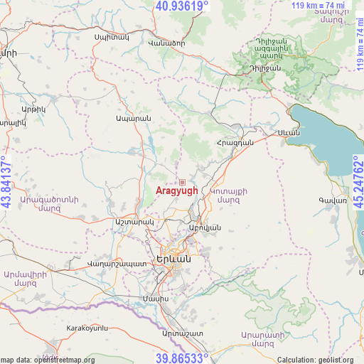
Aragyugh GPS coordinates[2]
40° 24' 10.404" North, 44° 32' 40.164" East
| Map corner | latitude | longitude |
|---|---|---|
| Upper-left | 40.93619°, | 43.84137° |
| Center: | 40.40289°, | 44.54449° |
| Lower-right: | 39.86533°, | 45.24762° |
| Map W x H: | 119.1×119.1 km | = 74×74mi |
| max Lat: | 41.24358° ⇑35% North |
| Aragyugh: | 40.40289° |
| min Lat: | ⇓65% South 38.90292° |
| min Long | Aragyugh | max Long |
| 43.74722° | 44.54449° | 46.5446° |
| W 51.3%⇐ | ⇒48.7% E |
Elevation
Elevation of Aragyugh is 1631 m = 5351 ft, and this is 329.5 m = 1081 ft above average elevation for this country.
| Max E: |
2169 m = 7116 ft | 28.7% |
| Aragyugh | 1631 m 5351 ft | |
| Avg. | 1301.5 m = 4270 ft | |
Min E: |
440 m = 1444 ft | 71.3% |
See also: Armenia elevation on elevation.city.
Geographical zone
Aragyugh is located in North temperate zone (between Tropic of Cancer and the Arctic Circle). Distance of this Northern Tropic circle is 1886.5 km =1172.2 mi to South.| Distance of | km | miles | from Aragyugh |
|---|---|---|---|
| North Pole | 5514.7 | 3426.7 | to North |
| Arctic Circle | 2908.8 | 1807.4 | to North |
| Tropic Cancer | 1886.5 | 1172.2 | to South |
| Equator | 4492.4 | 2791.4 | to South |


Nearby cities:
15 places around Aragyugh: (largest is in red/bold)
• Argel
5.5 km =3.4 mi,  120°
120°
• Arzakan
7.5 km =4.7 mi,  45°
45°
• Arzni
12.6 km =7.8 mi,  158°
158°
• Bjni
10.9 km =6.8 mi,  55°
55°
• Buzhakan
6.2 km =3.9 mi,  340°
340°
• Byureghavan
10.7 km =6.6 mi, 157°
• Fantan
12 km =7.5 mi,  94°
94°
• Kaputan
15.8 km =9.8 mi, 123°
• Mrgashen
13 km =8.1 mi,  180°
180°
• Nor Geghi
9.5 km =5.9 mi, 159°
• Solak
15.3 km =9.5 mi, 64°
• Ushi
15.6 km =9.7 mi,  246°
246°
• Yeghvard
10 km =6.2 mi,  209°
209°
• Zoravan
5.6 km =3.5 mi,  199°
199°
• Zovuni
15 km =9.3 mi,  323°
323°
Sources, notices
• [Note1] Compared only with cities in Armenia existing in our database
• [Src1] Map data: © OpenStreetMap contributors (CC-BY-SA)
• [Src2] Other city data from geonames.org with taken over terms of usage.
• [Src3] Geographical zone / Annual Mean Temperature by Robert A. Rohde @ Wikipedia
