Kosh geodata
Kosh (Aragatsotn) is a populated place; located in Armenia in Asia/Yerevan (GMT+4) time zone. With population of 2,581 people, there are 110 cities with bigger population in this country. Compared to other cities in Armenia, 58.9% of cities are located further ↓South; 81.8% of cities are located further →East and 54.1% of cities have higher elevation than Kosh. Note1


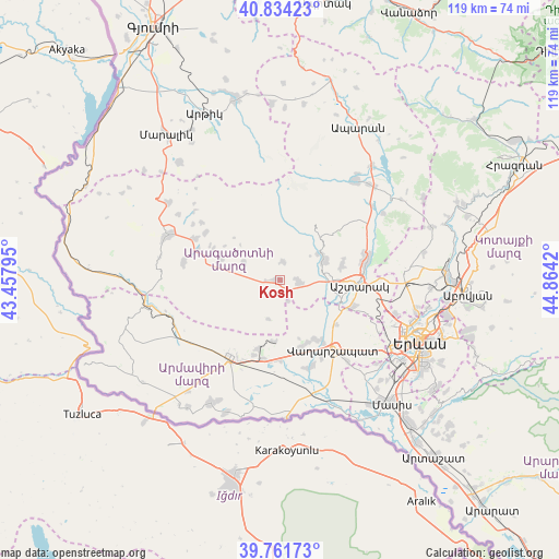
Kosh GPS coordinates[2]
40° 18' 0.396" North, 44° 9' 39.852" East
| Map corner | latitude | longitude |
|---|---|---|
| Upper-left | 40.83423°, | 43.45795° |
| Center: | 40.30011°, | 44.16107° |
| Lower-right: | 39.76173°, | 44.8642° |
| Map W x H: | 119.3×119.2 km | = 74.1×74.1mi |
| max Lat: | 41.24358° ⇑41.1% North |
| Kosh: | 40.30011° |
| min Lat: | ⇓58.9% South 38.90292° |
| min Long | Kosh | max Long |
| 43.74722° | 44.16107° | 46.5446° |
| W 18.2%⇐ | ⇒81.8% E |
Elevation
Elevation of Kosh is 1205 m = 3953 ft, and this is 96.5 m = 317 ft below average elevation for this country.
| Max E: |
2169 m = 7116 ft | 54.1% |
| Avg. | 1301.5 m = 4270 ft | |
| Kosh | 1205 m = 3953 ft | |
Min E: |
440 m = 1444 ft | 45.9% |
See also: Armenia elevation on elevation.city.
Geographical zone
Kosh is located in North temperate zone (between Tropic of Cancer and the Arctic Circle). Distance of this Northern Tropic circle is 1875 km =1165.1 mi to South.| Distance of | km | miles | from Kosh |
|---|---|---|---|
| North Pole | 5526.1 | 3433.8 | to North |
| Arctic Circle | 2920.2 | 1814.5 | to North |
| Tropic Cancer | 1875 | 1165.1 | to South |
| Equator | 4481 | 2784.4 | to South |


Nearby cities:
15 places around Kosh: (largest is in red/bold)
• Agarakavan
8.3 km =5.2 mi,  294°
294°
• Aghavnatun
10.8 km =6.7 mi,  133°
133°
• Arshaluys
15.2 km =9.4 mi,  162°
162°
• Ashtarak
17 km =10.6 mi,  90°
90°
• Aygeshat
13 km =8.1 mi,  123°
123°
• Byurakan
10.4 km =6.5 mi,  65°
65°
• Doghs
12.8 km =8 mi, 132°
• Geghakert
14.6 km =9.1 mi,  151°
151°
• Gmbet’
11.6 km =7.2 mi,  137°
137°
• Hovtamej
15.4 km =9.6 mi, 147°
• Oshakan
13.8 km =8.6 mi,  106°
106°
• Sasunik
16.5 km =10.3 mi, 109°
• Tsaghkunk’
16.3 km =10.1 mi, 144°
• Tsiatsan
15.7 km =9.8 mi, 144°
• Voskevaz
12.1 km =7.5 mi,  103°
103°
Sources, notices
• [Note1] Compared only with cities in Armenia existing in our database
• [Src1] Map data: © OpenStreetMap contributors (CC-BY-SA)
• [Src2] Other city data from geonames.org with taken over terms of usage.
• [Src3] Geographical zone / Annual Mean Temperature by Robert A. Rohde @ Wikipedia
