Byurakan geodata
Byurakan (Aragatsotn) is a populated place; located in Armenia in Asia/Yerevan (GMT+4) time zone. With population of 3,902 people, there are 68 cities with bigger population in this country. Compared to other cities in Armenia, 62.4% of cities are located further ↓South; 73.9% of cities are located further →East and 62.1% of cities have lower elevation than Byurakan. Note1


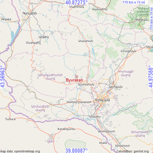
Byurakan GPS coordinates[2]
40° 20' 20.184" North, 44° 16' 21.9" East
| Map corner | latitude | longitude |
|---|---|---|
| Upper-left | 40.87275°, | 43.56963° |
| Center: | 40.33894°, | 44.27275° |
| Lower-right: | 39.80087°, | 44.97588° |
| Map W x H: | 119.2×119.2 km | = 74.1×74.1mi |
| max Lat: | 41.24358° ⇑37.6% North |
| Byurakan: | 40.33894° |
| min Lat: | ⇓62.4% South 38.90292° |
| min Long | Byurakan | max Long |
| 43.74722° | 44.27275° | 46.5446° |
| W 26.1%⇐ | ⇒73.9% E |
Elevation
Elevation of Byurakan is 1489 m = 4885 ft, and this is 187.5 m = 615 ft above average elevation for this country.
| Max E: |
2169 m = 7116 ft | 37.9% |
| Byurakan | 1489 m 4885 ft | |
| Avg. | 1301.5 m = 4270 ft | |
Min E: |
440 m = 1444 ft | 62.1% |
See also: Armenia elevation on elevation.city.
Geographical zone
Byurakan is located in North temperate zone (between Tropic of Cancer and the Arctic Circle). Distance of this Northern Tropic circle is 1879.4 km =1167.8 mi to South.| Distance of | km | miles | from Byurakan |
|---|---|---|---|
| North Pole | 5521.8 | 3431.1 | to North |
| Arctic Circle | 2915.9 | 1811.9 | to North |
| Tropic Cancer | 1879.4 | 1167.8 | to South |
| Equator | 4485.3 | 2787 | to South |


Nearby cities:
15 places around Byurakan: (largest is in red/bold)
• Agarakavan
17 km =10.6 mi,  266°
266°
• Aghavnatun
11.9 km =7.4 mi,  188°
188°
• Ashtarak
8.8 km =5.5 mi,  120°
120°
• Aygeshat
11.5 km =7.1 mi,  173°
173°
• Doghs
13 km =8.1 mi,  180°
180°
• Gmbet’
12.9 km =8 mi, 187°
• Karbi
9 km =5.6 mi,  95°
95°
• Kosh
10.4 km =6.5 mi,  245°
245°
• Nor Yerznka
10.8 km =6.7 mi,  113°
113°
• Oshakan
9.1 km =5.7 mi,  155°
155°
• Prroshyan
16.1 km =10 mi,  129°
129°
• Sasunik
11.6 km =7.2 mi,  148°
148°
• Tsiatsan
17 km =10.6 mi, 180°
• Ushi
8.7 km =5.4 mi,  83°
83°
• Voskevaz
7.5 km =4.7 mi, 161°
Sources, notices
• [Note1] Compared only with cities in Armenia existing in our database
• [Src1] Map data: © OpenStreetMap contributors (CC-BY-SA)
• [Src2] Other city data from geonames.org with taken over terms of usage.
• [Src3] Geographical zone / Annual Mean Temperature by Robert A. Rohde @ Wikipedia
