Gavarr geodata
Gavarr (Gegharkunik) is a seat of a first-order administrative division; located in Armenia in Asia/Yerevan (GMT+4) time zone. With population of 21,680 people, there are 10 cities with bigger population in this country. Compared to other cities in Armenia, 63.1% of cities are located further ↓South; 78.7% of cities are located further ←West and 92% of cities have lower elevation than Gavarr. Note1


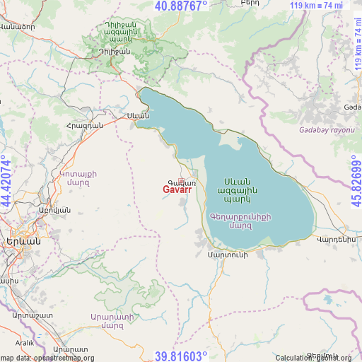
Gavarr GPS coordinates[2]
40° 21' 14.328" North, 45° 7' 25.896" East
| Map corner | latitude | longitude |
|---|---|---|
| Upper-left | 40.88767°, | 44.42074° |
| Center: | 40.35398°, | 45.12386° |
| Lower-right: | 39.81603°, | 45.82699° |
| Map W x H: | 119.2×119.2 km | = 74.1×74.1mi |
| max Lat: | 41.24358° ⇑36.9% North |
| Gavarr: | 40.35398° |
| min Lat: | ⇓63.1% South 38.90292° |
| min Long | Gavarr | max Long |
| 43.74722° | 45.12386° | 46.5446° |
| W 78.7%⇐ | ⇒21.3% E |
Elevation
Elevation of Gavarr is 1953 m = 6407 ft, and this is 651.5 m = 2137 ft above average elevation for this country.
| Max E: |
2169 m = 7116 ft | 8% |
| Gavarr | 1953 m 6407 ft | |
| Avg. | 1301.5 m = 4270 ft | |
Min E: |
440 m = 1444 ft | 92% |
See also: Armenia elevation on elevation.city.
Geographical zone
Gavarr is located in North temperate zone (between Tropic of Cancer and the Arctic Circle). Distance of this Northern Tropic circle is 1881 km =1168.8 mi to South.| Distance of | km | miles | from Gavarr |
|---|---|---|---|
| North Pole | 5520.1 | 3430 | to North |
| Arctic Circle | 2914.2 | 1810.8 | to North |
| Tropic Cancer | 1881 | 1168.8 | to South |
| Equator | 4486.9 | 2788 | to South |


Nearby cities:
15 places around Gavarr: (largest is in red/bold)
• Drakhtik
25.3 km =15.7 mi,  22°
22°
• Dzoragyugh
21.1 km =13.1 mi,  166°
166°
• Gandzak
4.5 km =2.8 mi,  193°
193°
• Lanjaghbyur
9.6 km =6 mi, 169°
• Lchap’
12 km =7.5 mi,  339°
339°
• Lchashen
24.6 km =15.3 mi,  318°
318°
• Lichk’
23.6 km =14.7 mi,  156°
156°
• Nerk’in Getashen
26.7 km =16.6 mi,  152°
152°
• Noratus
5.5 km =3.4 mi,  60°
60°
• Sarukhan
7 km =4.3 mi,  175°
175°
• Sevan
26.4 km =16.4 mi, 324°
• Tsovasar
24.7 km =15.3 mi, 166°
• Tsovazard
14.8 km =9.2 mi, 335°
• Vardadzor
19.4 km =12.1 mi, 162°
• Yeranos
17.6 km =10.9 mi, 160°
Sources, notices
• [Note1] Compared only with cities in Armenia existing in our database
• [Src1] Map data: © OpenStreetMap contributors (CC-BY-SA)
• [Src2] Other city data from geonames.org with taken over terms of usage.
• [Src3] Geographical zone / Annual Mean Temperature by Robert A. Rohde @ Wikipedia
