Gandzak geodata
Gandzak (Gegharkunik) is a populated place; located in Armenia in Asia/Yerevan (GMT+4) time zone. With population of 3,841 people, there are 70 cities with bigger population in this country. Compared to other cities in Armenia, 60.2% of cities are located further ↓South; 78.3% of cities are located further ←West and 95.5% of cities have lower elevation than Gandzak. Note1


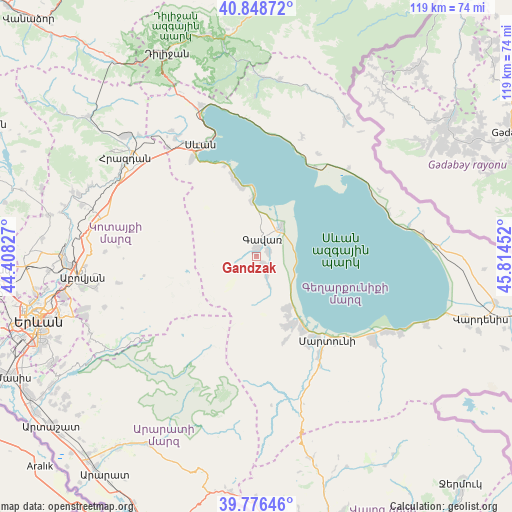
Gandzak GPS coordinates[2]
40° 18' 52.992" North, 45° 6' 41.004" East
| Map corner | latitude | longitude |
|---|---|---|
| Upper-left | 40.84872°, | 44.40827° |
| Center: | 40.31472°, | 45.11139° |
| Lower-right: | 39.77646°, | 45.81452° |
| Map W x H: | 119.2×119.2 km | = 74.1×74.1mi |
| max Lat: | 41.24358° ⇑39.8% North |
| Gandzak: | 40.31472° |
| min Lat: | ⇓60.2% South 38.90292° |
| min Long | Gandzak | max Long |
| 43.74722° | 45.11139° | 46.5446° |
| W 78.3%⇐ | ⇒21.7% E |
Elevation
Elevation of Gandzak is 1989 m = 6526 ft, and this is 687.5 m = 2256 ft above average elevation for this country.
| Max E: |
2169 m = 7116 ft | 4.5% |
| Gandzak | 1989 m 6526 ft | |
| Avg. | 1301.5 m = 4270 ft | |
Min E: |
440 m = 1444 ft | 95.5% |
See also: Armenia elevation on elevation.city.
Geographical zone
Gandzak is located in North temperate zone (between Tropic of Cancer and the Arctic Circle). Distance of this Northern Tropic circle is 1876.7 km =1166.1 mi to South.| Distance of | km | miles | from Gandzak |
|---|---|---|---|
| North Pole | 5524.5 | 3432.8 | to North |
| Arctic Circle | 2918.6 | 1813.5 | to North |
| Tropic Cancer | 1876.7 | 1166.1 | to South |
| Equator | 4482.6 | 2785.4 | to South |


Nearby cities:
15 places around Gandzak: (largest is in red/bold)
• Dzoragyugh
17.3 km =10.7 mi,  159°
159°
• Gavarr
4.5 km =2.8 mi,  13°
13°
• Lanjaghbyur
5.8 km =3.6 mi,  150°
150°
• Lchap’
16 km =9.9 mi,  348°
348°
• Lichk’
20.2 km =12.6 mi, 148°
• Martuni
25.6 km =15.9 mi,  139°
139°
• Nerk’in Getashen
23.5 km =14.6 mi, 144°
• Noratus
9.1 km =5.7 mi,  39°
39°
• Sarukhan
3 km =1.9 mi, 147°
• Tsovasar
20.8 km =12.9 mi, 161°
• Tsovazard
18.6 km =11.6 mi,  343°
343°
• Vaghashen
27.2 km =16.9 mi, 136°
• Vardadzor
15.8 km =9.8 mi, 154°
• Verin Getashen
23.7 km =14.7 mi, 149°
• Yeranos
14.1 km =8.8 mi, 150°
Sources, notices
• [Note1] Compared only with cities in Armenia existing in our database
• [Src1] Map data: © OpenStreetMap contributors (CC-BY-SA)
• [Src2] Other city data from geonames.org with taken over terms of usage.
• [Src3] Geographical zone / Annual Mean Temperature by Robert A. Rohde @ Wikipedia
