Lenughi geodata
Lenughi (Armavir) is a populated place; located in Armenia in Asia/Yerevan (GMT+4) time zone. With population of 1,499 people, there are 224 cities with bigger population in this country. Compared to other cities in Armenia, 64.6% of cities are located further ↑North; 91.4% of cities are located further →East and 67.8% of cities have higher elevation than Lenughi. Note1


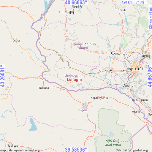
Lenughi GPS coordinates[2]
40° 7' 30.432" North, 43° 57' 50.148" East
| Map corner | latitude | longitude |
|---|---|---|
| Upper-left | 40.66063°, | 43.26081° |
| Center: | 40.12512°, | 43.96393° |
| Lower-right: | 39.58536°, | 44.66706° |
| Map W x H: | 119.6×119.6 km | = 74.3×74.3mi |
| max Lat: | 41.24358° ⇑64.6% North |
| Lenughi: | 40.12512° |
| min Lat: | ⇓35.4% South 38.90292° |
| min Long | Lenughi | max Long |
| 43.74722° | 43.96393° | 46.5446° |
| W 8.6%⇐ | ⇒91.4% E |
Elevation
Elevation of Lenughi is 887 m = 2910 ft, and this is 414.5 m = 1360 ft below average elevation for this country.
| Max E: |
2169 m = 7116 ft | 67.8% |
| Avg. | 1301.5 m = 4270 ft | |
| Lenughi | 887 m = 2910 ft | |
Min E: |
440 m = 1444 ft | 32.2% |
See also: Armenia elevation on elevation.city.
Geographical zone
Lenughi is located in North temperate zone (between Tropic of Cancer and the Arctic Circle). Distance of this Northern Tropic circle is 1855.6 km =1153 mi to South.| Distance of | km | miles | from Lenughi |
|---|---|---|---|
| North Pole | 5545.6 | 3445.9 | to North |
| Arctic Circle | 2939.7 | 1826.6 | to North |
| Tropic Cancer | 1855.6 | 1153 | to South |
| Equator | 4461.5 | 2772.2 | to South |


Nearby cities:
15 places around Lenughi: (largest is in red/bold)
• Alashkert
7.7 km =4.8 mi,  105°
105°
• Arevik
11.4 km =7.1 mi,  104°
104°
• Armavir
7.1 km =4.4 mi,  62°
62°
• Aygeshat
10 km =6.2 mi,  123°
123°
• Bambakashat
5.1 km =3.2 mi, 111°
• Getashen
9.2 km =5.7 mi,  191°
191°
• Janfida
10.5 km =6.5 mi,  148°
148°
• Lukashin
7.7 km =4.8 mi,  26°
26°
• Mayisyan
11.4 km =7.1 mi,  71°
71°
• Mrgashat
9.9 km =6.2 mi,  86°
86°
• Myasnikyan
7.2 km =4.5 mi,  328°
328°
• Nalbandyan
7.1 km =4.4 mi,  162°
162°
• Nor Armavir
5.1 km =3.2 mi, 149°
• Sardarapat
4 km =2.5 mi,  78°
78°
• Shenavan
8.2 km =5.1 mi,  200°
200°
Sources, notices
• [Note1] Compared only with cities in Armenia existing in our database
• [Src1] Map data: © OpenStreetMap contributors (CC-BY-SA)
• [Src2] Other city data from geonames.org with taken over terms of usage.
• [Src3] Geographical zone / Annual Mean Temperature by Robert A. Rohde @ Wikipedia
