San Lorenzo geodata
San Lorenzo (Corrientes) is a populated place; located in Argentina in America/Argentina/Cordoba (GMT-3) time zone. With population of 47,626 people, there are 92 cities with bigger population in this country. Compared to other cities in Argentina, 73.6% of cities are located further ↓South; 79.1% of cities are located further ←West and 78.2% of cities have higher elevation than San Lorenzo. Note1


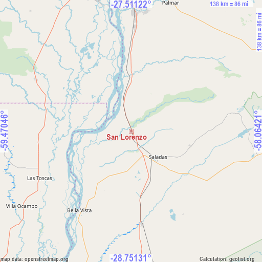
San Lorenzo GPS coordinates[2]
28° 7' 59.016" South, 58° 46' 2.388" West
| Map corner | latitude | longitude |
|---|---|---|
| Upper-left | -27.51122°, | -59.47046° |
| Center: | -28.13306°, | -58.76733° |
| Lower-right: | -28.75131°, | -58.06421° |
| Map W x H: | 137.9×137.9 km | = 85.7×85.7mi |
| max Lat: | -21.94467° ⇑26.4% North |
| San Lorenzo: | -28.13306° |
| min Lat: | ⇓73.6% South -54.81084° |
| min Long | San Lorenzo | max Long |
| -72.88605° | -58.76733° | -53.64581° |
| W 79.1%⇐ | ⇒20.9% E |
Elevation
Elevation of San Lorenzo is 64 m = 210 ft, and this is 285.3 m = 936 ft below average elevation for this country.
| Max E: |
4040 m = 13255 ft | 78.2% |
| Avg. | 349.3 m = 1146 ft | |
| San Lorenzo | 64 m = 210 ft | |
Min E: |
-2 m = -7 ft | 21.8% |
See also: San Lorenzo elevation on elevation.city.
Geographical zone
San Lorenzo is located in South temperate zone (between Tropic of Capricorn and the Antarctic Circle). Distance of this Southern Tropic circle is 522.2 km =324.5 mi to North.| Distance of | km | miles | from San Lorenzo |
|---|---|---|---|
| Equator | 3128.1 | 1943.7 | to North |
| Tropic Capricorn | 522.2 | 324.5 | to North |
| Antarctic Circle | 4273.1 | 2655.2 | to South |
| South Pole | 6879 | 4274.4 | to South |


Nearby cities:
15 places around San Lorenzo: (largest is in red/bold)
• Basail
57.6 km =35.8 mi,  298°
298°
• Bella Vista
49.5 km =30.8 mi,  212°
212°
• Corrientes
74.3 km =46.2 mi,  354°
354°
• Empedrado
20.5 km =12.7 mi, 349°
• Las Toscas
53.9 km =33.5 mi,  243°
243°
• Mburucuyá
53.8 km =33.4 mi,  79°
79°
• Pedro R. Fernández
69.6 km =43.2 mi,  170°
170°
• Puerto Vilelas
70.9 km =44.1 mi, 346°
• Riachuelo
61.3 km =38.1 mi,  2°
2°
• Saladas
19.3 km =12 mi,  134°
134°
• San Luis del Palmar
72.6 km =45.1 mi,  16°
16°
• San Roque
49.4 km =30.7 mi, 173°
• Santa Rosa
65.2 km =40.5 mi,  102°
102°
• Tacuarendí
57.4 km =35.7 mi, 237°
• Villa Ocampo
69.7 km =43.3 mi, 235°
Sources, notices
• [Note1] Compared only with cities in Argentina existing in our database
• [Src1] Map data: © OpenStreetMap contributors (CC-BY-SA)
• [Src2] Other city data from geonames.org with taken over terms of usage.
• [Src3] Geographical zone / Annual Mean Temperature by Robert A. Rohde @ Wikipedia
