Pronunciamiento geodata
Pronunciamiento (Entre Rios) is a populated place; located in Argentina in America/Argentina/Cordoba (GMT-3) time zone. With population of 1,301 people, there are 726 cities with bigger population in this country. Compared to other cities in Argentina, 55.2% of cities are located further ↑North; 84.7% of cities are located further ←West and 84.8% of cities have higher elevation than Pronunciamiento. Note1


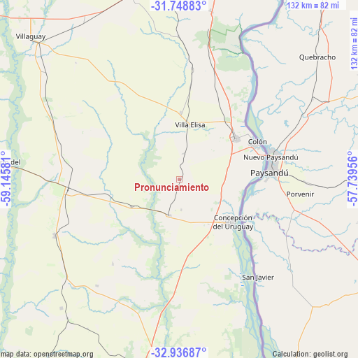
Pronunciamiento GPS coordinates[2]
32° 20' 41.28" South, 58° 26' 33.648" West
| Map corner | latitude | longitude |
|---|---|---|
| Upper-left | -31.74883°, | -59.14581° |
| Center: | -32.3448°, | -58.44268° |
| Lower-right: | -32.93687°, | -57.73956° |
| Map W x H: | 132.1×132.1 km | = 82.1×82.1mi |
| max Lat: | -21.94467° ⇑55.2% North |
| Pronunciamiento: | -32.3448° |
| min Lat: | ⇓44.8% South -54.81084° |
| min Long | Pronunciamiento | max Long |
| -72.88605° | -58.44268° | -53.64581° |
| W 84.7%⇐ | ⇒15.3% E |
Elevation
Elevation of Pronunciamiento is 47 m = 154 ft, and this is 302.3 m = 992 ft below average elevation for this country.
| Max E: |
4040 m = 13255 ft | 84.8% |
| Avg. | 349.3 m = 1146 ft | |
| Pronunciamiento | 47 m = 154 ft | |
Min E: |
-2 m = -7 ft | 15.2% |
See also: Argentina elevation on elevation.city.
Geographical zone
Pronunciamiento is located in South temperate zone (between Tropic of Capricorn and the Antarctic Circle). Distance of this Southern Tropic circle is 990.5 km =615.5 mi to North.| Distance of | km | miles | from Pronunciamiento |
|---|---|---|---|
| Equator | 3596.4 | 2234.7 | to North |
| Tropic Capricorn | 990.5 | 615.5 | to North |
| Antarctic Circle | 3804.8 | 2364.2 | to South |
| South Pole | 6410.7 | 3983.4 | to South |


Nearby cities:
15 places around Pronunciamiento: (largest is in red/bold)
• Aldea San Antonio
39.5 km =24.5 mi,  218°
218°
• Caseros
13.6 km =8.5 mi,  194°
194°
• Colonia Elía
37.9 km =23.5 mi,  163°
163°
• Colón
31.1 km =19.3 mi,  64°
64°
• Concepción del Uruguay
25.1 km =15.6 mi,  128°
128°
• Domínguez
63 km =39.1 mi,  309°
309°
• Gilbert
50.5 km =31.4 mi,  245°
245°
• Herrera
20.3 km =12.6 mi,  240°
240°
• Rosario del Tala
66.2 km =41.1 mi,  274°
274°
• San Justo
11.3 km =7 mi,  176°
176°
• Santa Anita
37.4 km =23.2 mi,  300°
300°
• Ubajay
62.5 km =38.8 mi,  11°
11°
• Urdinarrain
56.8 km =35.3 mi,  228°
228°
• Villa Elisa
20.6 km =12.8 mi, 11°
• Villa Mantero
29.1 km =18.1 mi,  258°
258°
Sources, notices
• [Note1] Compared only with cities in Argentina existing in our database
• [Src1] Map data: © OpenStreetMap contributors (CC-BY-SA)
• [Src2] Other city data from geonames.org with taken over terms of usage.
• [Src3] Geographical zone / Annual Mean Temperature by Robert A. Rohde @ Wikipedia
