Ubajay geodata
Ubajay (Entre Rios) is a populated place; located in Argentina in America/Argentina/Cordoba (GMT-3) time zone. With population of 2,334 people, there are 603 cities with bigger population in this country. Compared to other cities in Argentina, 50.3% of cities are located further ↓South; 86.6% of cities are located further ←West and 82.2% of cities have higher elevation than Ubajay. Note1


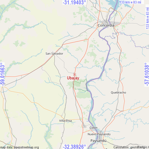
Ubajay GPS coordinates[2]
31° 47' 36.888" South, 58° 18' 48.6" West
| Map corner | latitude | longitude |
|---|---|---|
| Upper-left | -31.19403°, | -59.01663° |
| Center: | -31.79358°, | -58.3135° |
| Lower-right: | -32.38926°, | -57.61038° |
| Map W x H: | 132.9×132.9 km | = 82.6×82.6mi |
| max Lat: | -21.94467° ⇑49.7% North |
| Ubajay: | -31.79358° |
| min Lat: | ⇓50.3% South -54.81084° |
| min Long | Ubajay | max Long |
| -72.88605° | -58.3135° | -53.64581° |
| W 86.6%⇐ | ⇒13.4% E |
Elevation
Elevation of Ubajay is 54 m = 177 ft, and this is 295.3 m = 969 ft below average elevation for this country.
| Max E: |
4040 m = 13255 ft | 82.2% |
| Avg. | 349.3 m = 1146 ft | |
| Ubajay | 54 m = 177 ft | |
Min E: |
-2 m = -7 ft | 17.8% |
See also: Argentina elevation on elevation.city.
Geographical zone
Ubajay is located in South temperate zone (between Tropic of Capricorn and the Antarctic Circle). Distance of this Southern Tropic circle is 929.2 km =577.4 mi to North.| Distance of | km | miles | from Ubajay |
|---|---|---|---|
| Equator | 3535.1 | 2196.6 | to North |
| Tropic Capricorn | 929.2 | 577.4 | to North |
| Antarctic Circle | 3866.1 | 2402.3 | to South |
| South Pole | 6471.9 | 4021.5 | to South |


Nearby cities:
15 places around Ubajay: (largest is in red/bold)
• Caseros
76.1 km =47.3 mi,  191°
191°
• Colón
50.4 km =31.3 mi,  161°
161°
• Concepción del Uruguay
77.2 km =48 mi,  174°
174°
• Concordia
52.5 km =32.6 mi,  31°
31°
• Domínguez
64.9 km =40.3 mi,  250°
250°
• General Campos
31.3 km =19.4 mi,  343°
343°
• La Criolla
61.6 km =38.3 mi,  18°
18°
• Los Charrúas
69.8 km =43.4 mi,  9°
9°
• Pronunciamiento
62.5 km =38.8 mi, 191°
• Puerto Yeruá
40.1 km =24.9 mi,  44°
44°
• San Justo
73.5 km =45.7 mi, 189°
• San Salvador
26.1 km =16.2 mi,  315°
315°
• Santa Anita
61.5 km =38.2 mi,  226°
226°
• Villa Elisa
41.9 km =26 mi, 191°
• Villaguay
67.9 km =42.2 mi,  263°
263°
Sources, notices
• [Note1] Compared only with cities in Argentina existing in our database
• [Src1] Map data: © OpenStreetMap contributors (CC-BY-SA)
• [Src2] Other city data from geonames.org with taken over terms of usage.
• [Src3] Geographical zone / Annual Mean Temperature by Robert A. Rohde @ Wikipedia
