Caseros geodata
Caseros (Entre Rios) is a populated place; located in Argentina in America/Argentina/Cordoba (GMT-3) time zone. With population of 2,109 people, there are 635 cities with bigger population in this country. Compared to other cities in Argentina, 56.5% of cities are located further ↑North; 84.1% of cities are located further ←West and 83.8% of cities have higher elevation than Caseros. Note1


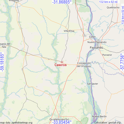
Caseros GPS coordinates[2]
32° 27' 47.7" South, 58° 28' 43.392" West
| Map corner | latitude | longitude |
|---|---|---|
| Upper-left | -31.86805°, | -59.18185° |
| Center: | -32.46325°, | -58.47872° |
| Lower-right: | -33.05454°, | -57.7756° |
| Map W x H: | 131.9×131.9 km | = 82×82mi |
| max Lat: | -21.94467° ⇑56.5% North |
| Caseros: | -32.46325° |
| min Lat: | ⇓43.5% South -54.81084° |
| min Long | Caseros | max Long |
| -72.88605° | -58.47872° | -53.64581° |
| W 84.1%⇐ | ⇒15.9% E |
Elevation
Elevation of Caseros is 51 m = 167 ft, and this is 298.3 m = 979 ft below average elevation for this country.
| Max E: |
4040 m = 13255 ft | 83.8% |
| Avg. | 349.3 m = 1146 ft | |
| Caseros | 51 m = 167 ft | |
Min E: |
-2 m = -7 ft | 16.2% |
See also: Argentina elevation on elevation.city.
Geographical zone
Caseros is located in South temperate zone (between Tropic of Capricorn and the Antarctic Circle). Distance of this Southern Tropic circle is 1003.7 km =623.7 mi to North.| Distance of | km | miles | from Caseros |
|---|---|---|---|
| Equator | 3609.6 | 2242.9 | to North |
| Tropic Capricorn | 1003.7 | 623.7 | to North |
| Antarctic Circle | 3791.6 | 2356 | to South |
| South Pole | 6397.5 | 3975.2 | to South |


Nearby cities:
15 places around Caseros: (largest is in red/bold)
• Aldea San Antonio
27.7 km =17.2 mi,  230°
230°
• Colonia Elía
27.2 km =16.9 mi,  148°
148°
• Colón
41.2 km =25.6 mi,  49°
49°
• Concepción del Uruguay
23.2 km =14.4 mi,  95°
95°
• Domínguez
69.8 km =43.4 mi,  319°
319°
• Gilbert
43.2 km =26.8 mi,  259°
259°
• Gualeguaychú
60.8 km =37.8 mi,  183°
183°
• Herrera
14.7 km =9.1 mi,  282°
282°
• Pronunciamiento
13.6 km =8.5 mi,  14°
14°
• Rosario del Tala
65.1 km =40.5 mi,  285°
285°
• San Justo
4.4 km =2.7 mi,  65°
65°
• Santa Anita
43.2 km =26.8 mi, 317°
• Urdinarrain
46 km =28.6 mi,  237°
237°
• Villa Elisa
34.2 km =21.3 mi, 12°
• Villa Mantero
26.1 km =16.2 mi, 286°
Sources, notices
• [Note1] Compared only with cities in Argentina existing in our database
• [Src1] Map data: © OpenStreetMap contributors (CC-BY-SA)
• [Src2] Other city data from geonames.org with taken over terms of usage.
• [Src3] Geographical zone / Annual Mean Temperature by Robert A. Rohde @ Wikipedia
