Gilbert geodata
Gilbert (Entre Rios) is a populated place; located in Argentina in America/Argentina/Cordoba (GMT-3) time zone. With population of 917 people, there are 775 cities with bigger population in this country. Compared to other cities in Argentina, 56.9% of cities are located further ↑North; 77.6% of cities are located further ←West and 76.5% of cities have higher elevation than Gilbert. Note1


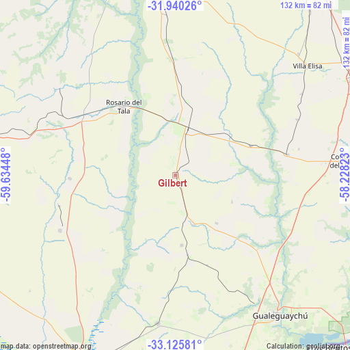
Gilbert GPS coordinates[2]
32° 32' 5.964" South, 58° 55' 52.86" West
| Map corner | latitude | longitude |
|---|---|---|
| Upper-left | -31.94026°, | -59.63448° |
| Center: | -32.53499°, | -58.93135° |
| Lower-right: | -33.12581°, | -58.22823° |
| Map W x H: | 131.8×131.8 km | = 81.9×81.9mi |
| max Lat: | -21.94467° ⇑56.9% North |
| Gilbert: | -32.53499° |
| min Lat: | ⇓43.1% South -54.81084° |
| min Long | Gilbert | max Long |
| -72.88605° | -58.93135° | -53.64581° |
| W 77.6%⇐ | ⇒22.4% E |
Elevation
Elevation of Gilbert is 67 m = 220 ft, and this is 282.3 m = 926 ft below average elevation for this country.
| Max E: |
4040 m = 13255 ft | 76.5% |
| Avg. | 349.3 m = 1146 ft | |
| Gilbert | 67 m = 220 ft | |
Min E: |
-2 m = -7 ft | 23.5% |
See also: Argentina elevation on elevation.city.
Geographical zone
Gilbert is located in South temperate zone (between Tropic of Capricorn and the Antarctic Circle). Distance of this Southern Tropic circle is 1011.6 km =628.6 mi to North.| Distance of | km | miles | from Gilbert |
|---|---|---|---|
| Equator | 3617.6 | 2247.9 | to North |
| Tropic Capricorn | 1011.6 | 628.6 | to North |
| Antarctic Circle | 3783.6 | 2351 | to South |
| South Pole | 6389.5 | 3970.3 | to South |


Nearby cities:
15 places around Gilbert: (largest is in red/bold)
• Aldea San Antonio
23.4 km =14.5 mi,  114°
114°
• Caseros
43.2 km =26.8 mi,  79°
79°
• Colonia Elía
58.8 km =36.5 mi,  104°
104°
• General Galarza
48.2 km =30 mi,  244°
244°
• Gobernador Mansilla
39.7 km =24.7 mi,  268°
268°
• Herrera
30.3 km =18.8 mi,  68°
68°
• Larroque
56.1 km =34.9 mi,  186°
186°
• Lucas González
58.6 km =36.4 mi,  286°
286°
• Maciá
59.7 km =37.1 mi,  312°
312°
• Pronunciamiento
50.5 km =31.4 mi, 65°
• Rosario del Tala
32.7 km =20.3 mi,  322°
322°
• San Justo
47.5 km =29.5 mi, 78°
• Santa Anita
42.3 km =26.3 mi,  18°
18°
• Urdinarrain
17.1 km =10.6 mi,  167°
167°
• Villa Mantero
23.2 km =14.4 mi,  48°
48°
Sources, notices
• [Note1] Compared only with cities in Argentina existing in our database
• [Src1] Map data: © OpenStreetMap contributors (CC-BY-SA)
• [Src2] Other city data from geonames.org with taken over terms of usage.
• [Src3] Geographical zone / Annual Mean Temperature by Robert A. Rohde @ Wikipedia
