Domínguez geodata
Domínguez (Entre Rios) is a populated place; located in Argentina in America/Argentina/Cordoba (GMT-3) time zone. With population of 1,925 people, there are 652 cities with bigger population in this country. Compared to other cities in Argentina, 51.8% of cities are located further ↑North; 76.8% of cities are located further ←West and 79.6% of cities have higher elevation than Domínguez. Note1


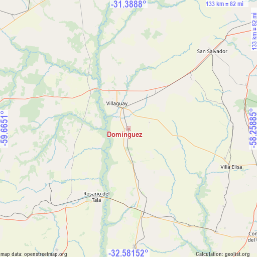
Domínguez GPS coordinates[2]
31° 59' 13.56" South, 58° 57' 43.092" West
| Map corner | latitude | longitude |
|---|---|---|
| Upper-left | -31.3888°, | -59.6651° |
| Center: | -31.9871°, | -58.96197° |
| Lower-right: | -32.58152°, | -58.25885° |
| Map W x H: | 132.6×132.6 km | = 82.4×82.4mi |
| max Lat: | -21.94467° ⇑51.8% North |
| Domínguez: | -31.9871° |
| min Lat: | ⇓48.2% South -54.81084° |
| min Long | Domínguez | max Long |
| -72.88605° | -58.96197° | -53.64581° |
| W 76.8%⇐ | ⇒23.2% E |
Elevation
Elevation of Domínguez is 59 m = 194 ft, and this is 290.3 m = 952 ft below average elevation for this country.
| Max E: |
4040 m = 13255 ft | 79.6% |
| Avg. | 349.3 m = 1146 ft | |
| Domínguez | 59 m = 194 ft | |
Min E: |
-2 m = -7 ft | 20.4% |
See also: Argentina elevation on elevation.city.
Geographical zone
Domínguez is located in South temperate zone (between Tropic of Capricorn and the Antarctic Circle). Distance of this Southern Tropic circle is 950.7 km =590.7 mi to North.| Distance of | km | miles | from Domínguez |
|---|---|---|---|
| Equator | 3556.6 | 2210 | to North |
| Tropic Capricorn | 950.7 | 590.7 | to North |
| Antarctic Circle | 3844.5 | 2388.9 | to South |
| South Pole | 6450.4 | 4008.1 | to South |


Nearby cities:
15 places around Domínguez: (largest is in red/bold)
• Caseros
69.8 km =43.4 mi,  139°
139°
• Gilbert
61 km =37.9 mi,  177°
177°
• Gobernador Mansilla
72.2 km =44.9 mi,  210°
210°
• Herrera
58.6 km =36.4 mi,  147°
147°
• Lucas González
69.3 km =43.1 mi,  230°
230°
• Maciá
46.1 km =28.6 mi,  243°
243°
• Pronunciamiento
63 km =39.1 mi,  129°
129°
• Rosario del Tala
39.1 km =24.3 mi, 206°
• San Justo
71.1 km =44.2 mi, 135°
• San Salvador
59 km =36.7 mi,  46°
46°
• Santa Anita
26.6 km =16.5 mi, 141°
• Ubajay
64.9 km =40.3 mi,  70°
70°
• Villa Elisa
56.4 km =35 mi,  110°
110°
• Villa Mantero
49.9 km =31 mi,  155°
155°
• Villaguay
14.9 km =9.3 mi,  335°
335°
Sources, notices
• [Note1] Compared only with cities in Argentina existing in our database
• [Src1] Map data: © OpenStreetMap contributors (CC-BY-SA)
• [Src2] Other city data from geonames.org with taken over terms of usage.
• [Src3] Geographical zone / Annual Mean Temperature by Robert A. Rohde @ Wikipedia
