Herrera geodata
Herrera (Entre Rios) is a populated place; located in Argentina in America/Argentina/Cordoba (GMT-3) time zone. With population of 1,587 people, there are 684 cities with bigger population in this country. Compared to other cities in Argentina, 56.2% of cities are located further ↑North; 81.6% of cities are located further ←West and 83.8% of cities have higher elevation than Herrera. Note1


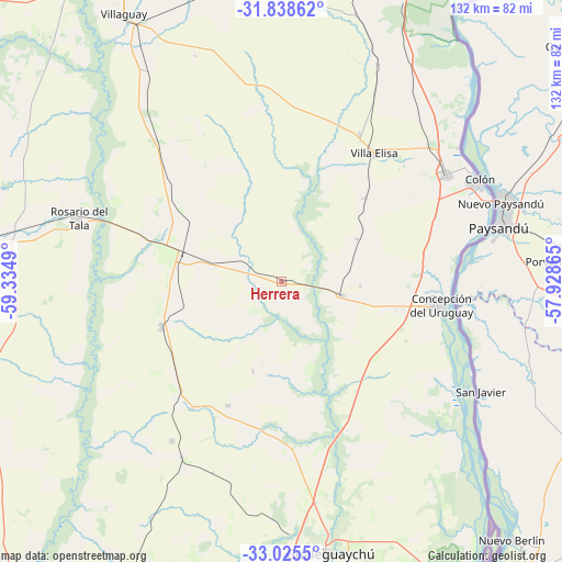
Herrera GPS coordinates[2]
32° 26' 2.436" South, 58° 37' 54.372" West
| Map corner | latitude | longitude |
|---|---|---|
| Upper-left | -31.83862°, | -59.3349° |
| Center: | -32.43401°, | -58.63177° |
| Lower-right: | -33.0255°, | -57.92865° |
| Map W x H: | 132×132 km | = 82×82mi |
| max Lat: | -21.94467° ⇑56.2% North |
| Herrera: | -32.43401° |
| min Lat: | ⇓43.8% South -54.81084° |
| min Long | Herrera | max Long |
| -72.88605° | -58.63177° | -53.64581° |
| W 81.6%⇐ | ⇒18.4% E |
Elevation
Elevation of Herrera is 51 m = 167 ft, and this is 298.3 m = 979 ft below average elevation for this country.
| Max E: |
4040 m = 13255 ft | 83.8% |
| Avg. | 349.3 m = 1146 ft | |
| Herrera | 51 m = 167 ft | |
Min E: |
-2 m = -7 ft | 16.2% |
See also: Argentina elevation on elevation.city.
Geographical zone
Herrera is located in South temperate zone (between Tropic of Capricorn and the Antarctic Circle). Distance of this Southern Tropic circle is 1000.4 km =621.6 mi to North.| Distance of | km | miles | from Herrera |
|---|---|---|---|
| Equator | 3606.3 | 2240.9 | to North |
| Tropic Capricorn | 1000.4 | 621.6 | to North |
| Antarctic Circle | 3794.9 | 2358 | to South |
| South Pole | 6400.7 | 3977.2 | to South |


Nearby cities:
15 places around Herrera: (largest is in red/bold)
• Aldea San Antonio
22.1 km =13.7 mi,  198°
198°
• Caseros
14.7 km =9.1 mi,  102°
102°
• Colonia Elía
39 km =24.2 mi,  132°
132°
• Colón
51.5 km =32 mi,  62°
62°
• Concepción del Uruguay
37.9 km =23.5 mi, 98°
• Domínguez
58.6 km =36.4 mi,  327°
327°
• Gilbert
30.3 km =18.8 mi,  248°
248°
• Gualeguaychú
64.9 km =40.3 mi,  170°
170°
• Pronunciamiento
20.3 km =12.6 mi, 60°
• Rosario del Tala
50.4 km =31.3 mi,  286°
286°
• San Justo
18.5 km =11.5 mi,  94°
94°
• Santa Anita
32.3 km =20.1 mi, 333°
• Urdinarrain
37.2 km =23.1 mi,  221°
221°
• Villa Elisa
37.1 km =23.1 mi,  35°
35°
• Villa Mantero
11.5 km =7.1 mi, 290°
Sources, notices
• [Note1] Compared only with cities in Argentina existing in our database
• [Src1] Map data: © OpenStreetMap contributors (CC-BY-SA)
• [Src2] Other city data from geonames.org with taken over terms of usage.
• [Src3] Geographical zone / Annual Mean Temperature by Robert A. Rohde @ Wikipedia
