Gualeguaychú geodata
Gualeguaychú (Entre Rios) is a seat of a second-order administrative division; located in Argentina in America/Argentina/Cordoba (GMT-3) time zone. With population of 78,676 people, there are 55 cities with bigger population in this country. Compared to other cities in Argentina, 62.1% of cities are located further ↑North; 83.3% of cities are located further ←West and 96.8% of cities have higher elevation than Gualeguaychú. Note1


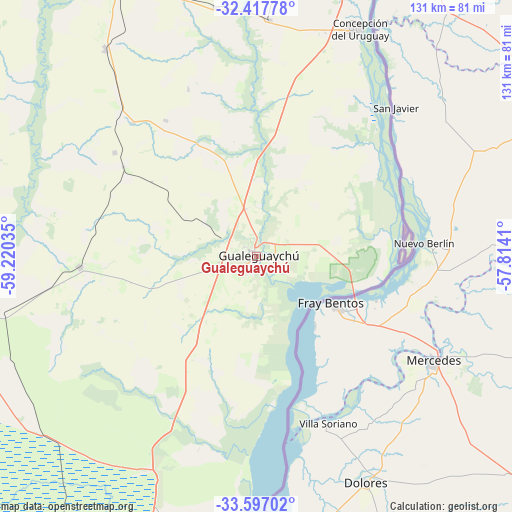
Gualeguaychú GPS coordinates[2]
33° 0' 33.732" South, 58° 31' 1.992" West
| Map corner | latitude | longitude |
|---|---|---|
| Upper-left | -32.41778°, | -59.22035° |
| Center: | -33.00937°, | -58.51722° |
| Lower-right: | -33.59702°, | -57.8141° |
| Map W x H: | 131.1×131.1 km | = 81.5×81.5mi |
| max Lat: | -21.94467° ⇑62.1% North |
| Gualeguaychú: | -33.00937° |
| min Lat: | ⇓37.9% South -54.81084° |
| min Long | Gualeguaychú | max Long |
| -72.88605° | -58.51722° | -53.64581° |
| W 83.3%⇐ | ⇒16.7% E |
Elevation
Elevation of Gualeguaychú is 14 m = 46 ft, and this is 335.3 m = 1100 ft below average elevation for this country.
| Max E: |
4040 m = 13255 ft | 96.8% |
| Avg. | 349.3 m = 1146 ft | |
| Gualeguaychú | 14 m = 46 ft | |
Min E: |
-2 m = -7 ft | 3.2% |
See also: Gualeguaychú elevation on elevation.city.
Geographical zone
Gualeguaychú is located in South temperate zone (between Tropic of Capricorn and the Antarctic Circle). Distance of this Southern Tropic circle is 1064.4 km =661.4 mi to North.| Distance of | km | miles | from Gualeguaychú |
|---|---|---|---|
| Equator | 3670.3 | 2280.6 | to North |
| Tropic Capricorn | 1064.4 | 661.4 | to North |
| Antarctic Circle | 3730.9 | 2318.3 | to South |
| South Pole | 6336.8 | 3937.5 | to South |


Nearby cities:
15 places around Gualeguaychú: (largest is in red/bold)
• Aldea San Antonio
46.4 km =28.8 mi,  337°
337°
• Caseros
60.8 km =37.8 mi,  3°
3°
• Ceibas
51.9 km =32.2 mi,  204°
204°
• Colonia Elía
41.6 km =25.8 mi,  25°
25°
• Concepción del Uruguay
64.1 km =39.8 mi,  24°
24°
• General Galarza
88.2 km =54.8 mi,  291°
291°
• Gilbert
65.4 km =40.6 mi,  323°
323°
• Gualeguay
75.3 km =46.8 mi,  258°
258°
• Herrera
64.9 km =40.3 mi,  350°
350°
• Larroque
45.2 km =28.1 mi,  266°
266°
• Pronunciamiento
74.2 km =46.1 mi,  5°
5°
• San Justo
63 km =39.1 mi, 6°
• Urdinarrain
50.3 km =31.3 mi, 315°
• Villa Mantero
71.3 km =44.3 mi, 342°
• Villa Paranacito
79.4 km =49.3 mi,  189°
189°
Sources, notices
• [Note1] Compared only with cities in Argentina existing in our database
• [Src1] Map data: © OpenStreetMap contributors (CC-BY-SA)
• [Src2] Other city data from geonames.org with taken over terms of usage.
• [Src3] Geographical zone / Annual Mean Temperature by Robert A. Rohde @ Wikipedia
