Hasenkamp geodata
Hasenkamp (Entre Rios) is a populated place; located in Argentina in America/Argentina/Cordoba (GMT-3) time zone. With population of 4,413 people, there are 472 cities with bigger population in this country. Compared to other cities in Argentina, 53.9% of cities are located further ↓South; 69.3% of cities are located further ←West and 66.6% of cities have higher elevation than Hasenkamp. Note1


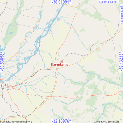
Hasenkamp GPS coordinates[2]
31° 30' 44.136" South, 59° 50' 7.62" West
| Map corner | latitude | longitude |
|---|---|---|
| Upper-left | -30.91091°, | -60.53858° |
| Center: | -31.51226°, | -59.83545° |
| Lower-right: | -32.10976°, | -59.13233° |
| Map W x H: | 133.3×133.3 km | = 82.8×82.8mi |
| max Lat: | -21.94467° ⇑46.1% North |
| Hasenkamp: | -31.51226° |
| min Lat: | ⇓53.9% South -54.81084° |
| min Long | Hasenkamp | max Long |
| -72.88605° | -59.83545° | -53.64581° |
| W 69.3%⇐ | ⇒30.7% E |
Elevation
Elevation of Hasenkamp is 90 m = 295 ft, and this is 259.3 m = 851 ft below average elevation for this country.
| Max E: |
4040 m = 13255 ft | 66.6% |
| Avg. | 349.3 m = 1146 ft | |
| Hasenkamp | 90 m = 295 ft | |
Min E: |
-2 m = -7 ft | 33.4% |
See also: Argentina elevation on elevation.city.
Geographical zone
Hasenkamp is located in South temperate zone (between Tropic of Capricorn and the Antarctic Circle). Distance of this Southern Tropic circle is 897.9 km =557.9 mi to North.| Distance of | km | miles | from Hasenkamp |
|---|---|---|---|
| Equator | 3503.8 | 2177.2 | to North |
| Tropic Capricorn | 897.9 | 557.9 | to North |
| Antarctic Circle | 3897.3 | 2421.7 | to South |
| South Pole | 6503.2 | 4040.9 | to South |


Nearby cities:
15 places around Hasenkamp: (largest is in red/bold)
• Bovril
41.5 km =25.8 mi,  63°
63°
• Crespo
72.7 km =45.2 mi,  217°
217°
• Helvecia
51.9 km =32.2 mi,  332°
332°
• Oro Verde
73.3 km =45.5 mi,  241°
241°
• Paraná
70.1 km =43.6 mi,  249°
249°
• Piedras Blancas
37.9 km =23.5 mi,  343°
343°
• San Benito
64.8 km =40.3 mi, 242°
• Santa Elena
63.3 km =39.3 mi,  4°
4°
• Sauce de Luna
66 km =41 mi, 62°
• Seguí
56.5 km =35.1 mi,  208°
208°
• Tabossi
33.5 km =20.8 mi,  196°
196°
• Viale
42.7 km =26.5 mi, 202°
• Villa Hernandarias
34.3 km =21.3 mi, 335°
• Villa María Grande
18.2 km =11.3 mi, 200°
• Villa Urquiza
53.3 km =33.1 mi, 253°
Sources, notices
• [Note1] Compared only with cities in Argentina existing in our database
• [Src1] Map data: © OpenStreetMap contributors (CC-BY-SA)
• [Src2] Other city data from geonames.org with taken over terms of usage.
• [Src3] Geographical zone / Annual Mean Temperature by Robert A. Rohde @ Wikipedia
