Bovril geodata
Bovril (Entre Rios) is a populated place; located in Argentina in America/Argentina/Cordoba (GMT-3) time zone. With population of 7,977 people, there are 339 cities with bigger population in this country. Compared to other cities in Argentina, 56.3% of cities are located further ↓South; 72.2% of cities are located further ←West and 69.2% of cities have higher elevation than Bovril. Note1


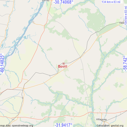
Bovril GPS coordinates[2]
31° 20' 35.196" South, 59° 26' 42.432" West
| Map corner | latitude | longitude |
|---|---|---|
| Upper-left | -30.74068°, | -60.14825° |
| Center: | -31.34311°, | -59.44512° |
| Lower-right: | -31.9417°, | -58.742° |
| Map W x H: | 133.5×133.5 km | = 83×83mi |
| max Lat: | -21.94467° ⇑43.7% North |
| Bovril: | -31.34311° |
| min Lat: | ⇓56.3% South -54.81084° |
| min Long | Bovril | max Long |
| -72.88605° | -59.44512° | -53.64581° |
| W 72.2%⇐ | ⇒27.8% E |
Elevation
Elevation of Bovril is 81 m = 266 ft, and this is 268.3 m = 880 ft below average elevation for this country.
| Max E: |
4040 m = 13255 ft | 69.2% |
| Avg. | 349.3 m = 1146 ft | |
| Bovril | 81 m = 266 ft | |
Min E: |
-2 m = -7 ft | 30.8% |
See also: Argentina elevation on elevation.city.
Geographical zone
Bovril is located in South temperate zone (between Tropic of Capricorn and the Antarctic Circle). Distance of this Southern Tropic circle is 879.1 km =546.2 mi to North.| Distance of | km | miles | from Bovril |
|---|---|---|---|
| Equator | 3485 | 2165.5 | to North |
| Tropic Capricorn | 879.1 | 546.2 | to North |
| Antarctic Circle | 3916.1 | 2433.4 | to South |
| South Pole | 6522 | 4052.6 | to South |


Nearby cities:
15 places around Bovril: (largest is in red/bold)
• Conscripto Bernardi
47.4 km =29.5 mi,  46°
46°
• Domínguez
85 km =52.8 mi,  147°
147°
• Federal
76.4 km =47.5 mi,  55°
55°
• Hasenkamp
41.5 km =25.8 mi,  243°
243°
• Helvecia
66.9 km =41.6 mi,  293°
293°
• La Paz
69.5 km =43.2 mi,  344°
344°
• Piedras Blancas
51.2 km =31.8 mi, 289°
• San Gustavo
72.8 km =45.2 mi,  3°
3°
• Santa Elena
55.1 km =34.2 mi,  323°
323°
• Sauce de Luna
24.5 km =15.2 mi, 61°
• Tabossi
68.9 km =42.8 mi,  222°
222°
• Viale
79 km =49.1 mi, 222°
• Villa Hernandarias
52.8 km =32.8 mi,  283°
283°
• Villa María Grande
56.2 km =34.9 mi,  230°
230°
• Villaguay
70.3 km =43.7 mi, 145°
Sources, notices
• [Note1] Compared only with cities in Argentina existing in our database
• [Src1] Map data: © OpenStreetMap contributors (CC-BY-SA)
• [Src2] Other city data from geonames.org with taken over terms of usage.
• [Src3] Geographical zone / Annual Mean Temperature by Robert A. Rohde @ Wikipedia
