Villa Urquiza geodata
Villa Urquiza (Entre Rios) is a populated place; located in Argentina in America/Argentina/Cordoba (GMT-3) time zone. With population of 1,566 people, there are 689 cities with bigger population in this country. Compared to other cities in Argentina, 52.6% of cities are located further ↓South; 65.4% of cities are located further ←West and 83.8% of cities have higher elevation than Villa Urquiza. Note1


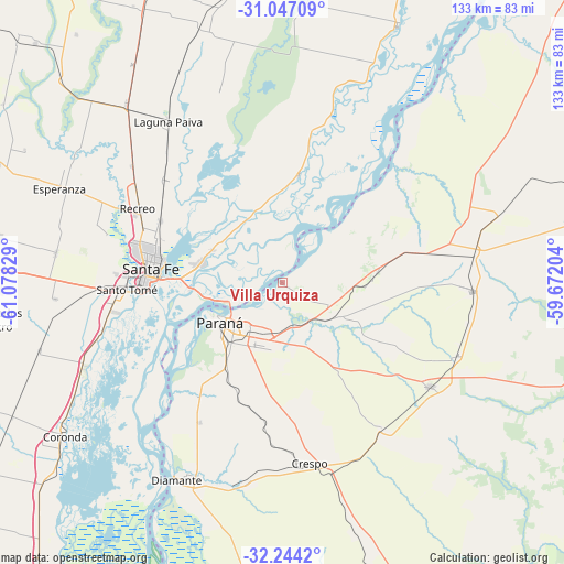
Villa Urquiza GPS coordinates[2]
31° 38' 51.252" South, 60° 22' 30.576" West
| Map corner | latitude | longitude |
|---|---|---|
| Upper-left | -31.04709°, | -61.07829° |
| Center: | -31.64757°, | -60.37516° |
| Lower-right: | -32.2442°, | -59.67204° |
| Map W x H: | 133.1×133.1 km | = 82.7×82.7mi |
| max Lat: | -21.94467° ⇑47.4% North |
| Villa Urquiza: | -31.64757° |
| min Lat: | ⇓52.6% South -54.81084° |
| min Long | Villa Urquiza | max Long |
| -72.88605° | -60.37516° | -53.64581° |
| W 65.4%⇐ | ⇒34.6% E |
Elevation
Elevation of Villa Urquiza is 51 m = 167 ft, and this is 298.3 m = 979 ft below average elevation for this country.
| Max E: |
4040 m = 13255 ft | 83.8% |
| Avg. | 349.3 m = 1146 ft | |
| Villa Urquiza | 51 m = 167 ft | |
Min E: |
-2 m = -7 ft | 16.2% |
See also: Argentina elevation on elevation.city.
Geographical zone
Villa Urquiza is located in South temperate zone (between Tropic of Capricorn and the Antarctic Circle). Distance of this Southern Tropic circle is 913 km =567.3 mi to North.| Distance of | km | miles | from Villa Urquiza |
|---|---|---|---|
| Equator | 3518.9 | 2186.5 | to North |
| Tropic Capricorn | 913 | 567.3 | to North |
| Antarctic Circle | 3882.3 | 2412.3 | to South |
| South Pole | 6488.2 | 4031.6 | to South |


Nearby cities:
15 places around Villa Urquiza: (largest is in red/bold)
• Crespo
42.9 km =26.7 mi,  171°
171°
• Diamante
52.8 km =32.8 mi,  208°
208°
• Esperanza
57.2 km =35.5 mi,  292°
292°
• Hasenkamp
53.3 km =33.1 mi,  73°
73°
• Laguna Paiva
46.7 km =29 mi,  324°
324°
• Oro Verde
23.9 km =14.9 mi, 214°
• Paraná
17.4 km =10.8 mi,  236°
236°
• Recreo
38.1 km =23.7 mi,  297°
297°
• San Benito
16.4 km =10.2 mi,  202°
202°
• Santa Fe
31.6 km =19.6 mi,  269°
269°
• Santo Tomé
37 km =23 mi, 267°
• Seguí
41.7 km =25.9 mi,  145°
145°
• Tabossi
45 km =28 mi,  112°
112°
• Viale
42.5 km =26.4 mi,  125°
125°
• Villa María Grande
44.8 km =27.8 mi,  92°
92°
Sources, notices
• [Note1] Compared only with cities in Argentina existing in our database
• [Src1] Map data: © OpenStreetMap contributors (CC-BY-SA)
• [Src2] Other city data from geonames.org with taken over terms of usage.
• [Src3] Geographical zone / Annual Mean Temperature by Robert A. Rohde @ Wikipedia
