Formosa geodata
Formosa is a seat of a first-order administrative division; located in Argentina in America/Argentina/Cordoba (GMT-3) time zone. With population of 221,383 people, there are 23 cities with bigger population in this country. Compared to other cities in Argentina, 91.8% of cities are located further ↓South; 88% of cities are located further ←West and 78.7% of cities have higher elevation than Formosa. Note1


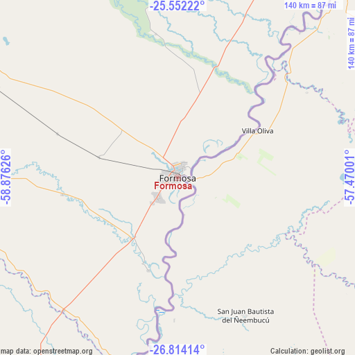
Formosa GPS coordinates[2]
26° 11' 5.604" South, 58° 10' 23.268" West
| Map corner | latitude | longitude |
|---|---|---|
| Upper-left | -25.55222°, | -58.87626° |
| Center: | -26.18489°, | -58.17313° |
| Lower-right: | -26.81414°, | -57.47001° |
| Map W x H: | 140.3×140.3 km | = 87.2×87.2mi |
| max Lat: | -21.94467° ⇑8.2% North |
| Formosa: | -26.18489° |
| min Lat: | ⇓91.8% South -54.81084° |
| min Long | Formosa | max Long |
| -72.88605° | -58.17313° | -53.64581° |
| W 88%⇐ | ⇒12% E |
Elevation
Elevation of Formosa is 62 m = 203 ft, and this is 287.3 m = 943 ft below average elevation for this country.
| Max E: |
4040 m = 13255 ft | 78.7% |
| Avg. | 349.3 m = 1146 ft | |
| Formosa | 62 m = 203 ft | |
Min E: |
-2 m = -7 ft | 21.3% |
See also: Formosa elevation on elevation.city.
Geographical zone
Formosa is located in South temperate zone (between Tropic of Capricorn and the Antarctic Circle). Distance of this Southern Tropic circle is 305.6 km =189.9 mi to North.| Distance of | km | miles | from Formosa |
|---|---|---|---|
| Equator | 2911.5 | 1809.1 | to North |
| Tropic Capricorn | 305.6 | 189.9 | to North |
| Antarctic Circle | 4489.7 | 2789.8 | to South |
| South Pole | 7095.6 | 4409 | to South |


Nearby cities:
15 places around Formosa: (largest is in red/bold)
• Clorinda
110 km =68.4 mi,  24°
24°
• El Colorado
120.4 km =74.8 mi,  263°
263°
• General José de San Martín
122.8 km =76.3 mi,  251°
251°
• General Vedia
96.3 km =59.8 mi,  210°
210°
• Herradura
36.3 km =22.6 mi,  202°
202°
• Itatí
120.9 km =75.1 mi,  183°
183°
• La Eduvigis
114.3 km =71 mi,  230°
230°
• La Leonesa
108.5 km =67.4 mi, 209°
• Laguna Naick-Neck
104.5 km =64.9 mi,  4°
4°
• Pampa Almirón
110.6 km =68.7 mi,  238°
238°
• Pirané
106.2 km =66 mi,  298°
298°
• Puerto Bermejo
89.1 km =55.4 mi, 202°
• Riacho Eh-Eh
92.1 km =57.2 mi,  353°
353°
• San Francisco de Laishí
46.1 km =28.6 mi, 261°
• Villa Escolar
69.5 km =43.2 mi, 225°
Sources, notices
• [Note1] Compared only with cities in Argentina existing in our database
• [Src1] Map data: © OpenStreetMap contributors (CC-BY-SA)
• [Src2] Other city data from geonames.org with taken over terms of usage.
• [Src3] Geographical zone / Annual Mean Temperature by Robert A. Rohde @ Wikipedia
