Clorinda geodata
Clorinda (Formosa) is a seat of a second-order administrative division; located in Argentina in America/Argentina/Cordoba (GMT-3) time zone. With population of 15,000 people, there are 226 cities with bigger population in this country. Compared to other cities in Argentina, 94.2% of cities are located further ↓South; 90.9% of cities are located further ←West and 76.9% of cities have higher elevation than Clorinda. Note1


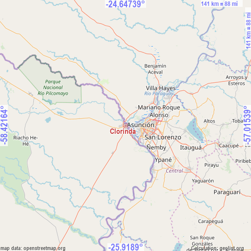
Clorinda GPS coordinates[2]
25° 17' 5.316" South, 57° 43' 6.636" West
| Map corner | latitude | longitude |
|---|---|---|
| Upper-left | -24.64739°, | -58.42164° |
| Center: | -25.28481°, | -57.71851° |
| Lower-right: | -25.9189°, | -57.01539° |
| Map W x H: | 141.4×141.4 km | = 87.9×87.9mi |
| max Lat: | -21.94467° ⇑5.8% North |
| Clorinda: | -25.28481° |
| min Lat: | ⇓94.2% South -54.81084° |
| min Long | Clorinda | max Long |
| -72.88605° | -57.71851° | -53.64581° |
| W 90.9%⇐ | ⇒9.1% E |
Elevation
Elevation of Clorinda is 66 m = 217 ft, and this is 283.3 m = 929 ft below average elevation for this country.
| Max E: |
4040 m = 13255 ft | 76.9% |
| Avg. | 349.3 m = 1146 ft | |
| Clorinda | 66 m = 217 ft | |
Min E: |
-2 m = -7 ft | 23.1% |
See also: Argentina elevation on elevation.city.
Geographical zone
Clorinda is located in South temperate zone (between Tropic of Capricorn and the Antarctic Circle). Distance of this Southern Tropic circle is 205.5 km =127.7 mi to North.| Distance of | km | miles | from Clorinda |
|---|---|---|---|
| Equator | 2811.4 | 1746.9 | to North |
| Tropic Capricorn | 205.5 | 127.7 | to North |
| Antarctic Circle | 4589.8 | 2852 | to South |
| South Pole | 7195.7 | 4471.2 | to South |


Nearby cities:
15 places around Clorinda: (largest is in red/bold)
• Comandante Fontana
197.5 km =122.7 mi,  268°
268°
• El Colorado
200.9 km =124.8 mi,  235°
235°
• Espinillo
90.4 km =56.2 mi,  291°
291°
• Formosa
110 km =68.4 mi,  204°
204°
• General Vedia
206.1 km =128.1 mi,  207°
207°
• Herradura
146.3 km =90.9 mi, 203°
• Laguna Naick-Neck
38 km =23.6 mi,  276°
276°
• Palo Santo
165.5 km =102.8 mi,  259°
259°
• Pirané
148.1 km =92 mi,  250°
250°
• Presidencia Roca
210.7 km =130.9 mi, 243°
• Puerto Bermejo
199 km =123.7 mi, 203°
• Riacho Eh-Eh
56.8 km =35.3 mi, 261°
• San Francisco de Laishí
140.3 km =87.2 mi,  220°
220°
• Villa Escolar
176.6 km =109.7 mi, 212°
• Villa General Guemes
187.9 km =116.8 mi, 288°
Sources, notices
• [Note1] Compared only with cities in Argentina existing in our database
• [Src1] Map data: © OpenStreetMap contributors (CC-BY-SA)
• [Src2] Other city data from geonames.org with taken over terms of usage.
• [Src3] Geographical zone / Annual Mean Temperature by Robert A. Rohde @ Wikipedia
