Laguna Naick-Neck geodata
Laguna Naick-Neck (Formosa) is a populated place; located in Argentina in America/Argentina/Cordoba (GMT-3) time zone. With population of 2,115 people, there are 633 cities with bigger population in this country. Compared to other cities in Argentina, 94.4% of cities are located further ↓South; 88.5% of cities are located further ←West and 70.9% of cities have higher elevation than Laguna Naick-Neck. Note1


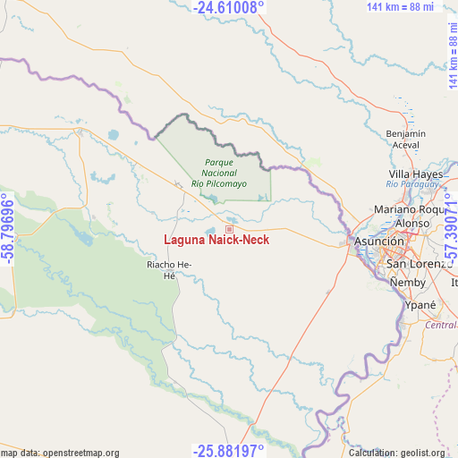
Laguna Naick-Neck GPS coordinates[2]
25° 14' 51.684" South, 58° 5' 37.788" West
| Map corner | latitude | longitude |
|---|---|---|
| Upper-left | -24.61008°, | -58.79696° |
| Center: | -25.24769°, | -58.09383° |
| Lower-right: | -25.88197°, | -57.39071° |
| Map W x H: | 141.4×141.4 km | = 87.9×87.9mi |
| max Lat: | -21.94467° ⇑5.6% North |
| Laguna Naick-Neck: | -25.24769° |
| min Lat: | ⇓94.4% South -54.81084° |
| min Long | Laguna Naick-Ne | max Long |
| -72.88605° | -58.09383° | -53.64581° |
| W 88.5%⇐ | ⇒11.5% E |
Elevation
Elevation of Laguna Naick-Neck is 78 m = 256 ft, and this is 271.3 m = 890 ft below average elevation for this country.
| Max E: |
4040 m = 13255 ft | 70.9% |
| Avg. | 349.3 m = 1146 ft | |
| Laguna Naick-Neck | 78 m = 256 ft | |
Min E: |
-2 m = -7 ft | 29.1% |
See also: Argentina elevation on elevation.city.
Geographical zone
Laguna Naick-Neck is located in South temperate zone (between Tropic of Capricorn and the Antarctic Circle). Distance of this Southern Tropic circle is 201.4 km =125.1 mi to North.| Distance of | km | miles | from Laguna Naick-Neck |
|---|---|---|---|
| Equator | 2807.3 | 1744.4 | to North |
| Tropic Capricorn | 201.4 | 125.1 | to North |
| Antarctic Circle | 4593.9 | 2854.5 | to South |
| South Pole | 7199.8 | 4473.7 | to South |


Nearby cities:
15 places around Laguna Naick-Neck: (largest is in red/bold)
• Clorinda
38 km =23.6 mi,  96°
96°
• Comandante Fontana
160 km =99.4 mi,  266°
266°
• El Colorado
174.1 km =108.2 mi,  227°
227°
• Espinillo
54.8 km =34.1 mi,  302°
302°
• Formosa
104.5 km =64.9 mi,  184°
184°
• General José de San Martín
190.1 km =118.1 mi,  221°
221°
• Herradura
139.5 km =86.7 mi,  188°
188°
• Ibarreta
177.5 km =110.3 mi, 271°
• Palo Santo
129.8 km =80.7 mi,  254°
254°
• Pirané
115.2 km =71.6 mi,  242°
242°
• Presidencia Roca
180.3 km =112 mi, 236°
• Riacho Eh-Eh
22.4 km =13.9 mi, 235°
• San Francisco de Laishí
123 km =76.4 mi,  205°
205°
• Villa Escolar
163.4 km =101.5 mi,  200°
200°
• Villa General Guemes
150.9 km =93.8 mi,  291°
291°
Sources, notices
• [Note1] Compared only with cities in Argentina existing in our database
• [Src1] Map data: © OpenStreetMap contributors (CC-BY-SA)
• [Src2] Other city data from geonames.org with taken over terms of usage.
• [Src3] Geographical zone / Annual Mean Temperature by Robert A. Rohde @ Wikipedia
