Balcarce geodata
Balcarce (Buenos Aires) is a seat of a second-order administrative division; located in Argentina in America/Argentina/Buenos_Aires (GMT-3) time zone. With population of 38,823 people, there are 108 cities with bigger population in this country. Compared to other cities in Argentina, 88.2% of cities are located further ↑North; 87.2% of cities are located further ←West and 54.4% of cities have higher elevation than Balcarce. Note1


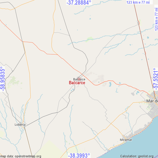
Balcarce GPS coordinates[2]
37° 50' 46.176" South, 58° 15' 18.792" West
| Map corner | latitude | longitude |
|---|---|---|
| Upper-left | -37.28884°, | -58.95835° |
| Center: | -37.84616°, | -58.25522° |
| Lower-right: | -38.3993°, | -57.5521° |
| Map W x H: | 123.5×123.5 km | = 76.7×76.7mi |
| max Lat: | -21.94467° ⇑88.2% North |
| Balcarce: | -37.84616° |
| min Lat: | ⇓11.8% South -54.81084° |
| min Long | Balcarce | max Long |
| -72.88605° | -58.25522° | -53.64581° |
| W 87.2%⇐ | ⇒12.8% E |
Elevation
Elevation of Balcarce is 126 m = 413 ft, and this is 223.3 m = 733 ft below average elevation for this country.
| Max E: |
4040 m = 13255 ft | 54.4% |
| Avg. | 349.3 m = 1146 ft | |
| Balcarce | 126 m = 413 ft | |
Min E: |
-2 m = -7 ft | 45.6% |
See also: Argentina elevation on elevation.city.
Geographical zone
Balcarce is located in South temperate zone (between Tropic of Capricorn and the Antarctic Circle). Distance of this Southern Tropic circle is 1602.2 km =995.6 mi to North.| Distance of | km | miles | from Balcarce |
|---|---|---|---|
| Equator | 4208.1 | 2614.8 | to North |
| Tropic Capricorn | 1602.2 | 995.6 | to North |
| Antarctic Circle | 3193.1 | 1984.1 | to South |
| South Pole | 5799 | 3603.3 | to South |


Nearby cities:
15 places around Balcarce: (largest is in red/bold)
• Ayacucho
79.9 km =49.6 mi,  345°
345°
• Benito Juárez
137.7 km =85.6 mi,  278°
278°
• Coronel Vidal
64.3 km =40 mi,  46°
46°
• General Guido
140.2 km =87.1 mi,  17°
17°
• General Juan Madariaga
136.4 km =84.8 mi, 46°
• Lobería
58.2 km =36.2 mi,  233°
233°
• Maipú
114.2 km =71 mi, 16°
• Mar de las Pampas
123.2 km =76.6 mi,  61°
61°
• Mar del Plata
63.7 km =39.6 mi,  105°
105°
• Miramar
59.7 km =37.1 mi,  142°
142°
• Necochea
89.4 km =55.6 mi,  208°
208°
• Rauch
140.2 km =87.1 mi,  328°
328°
• San Cayetano
130.9 km =81.3 mi,  244°
244°
• Tandil
96.9 km =60.2 mi,  307°
307°
• Villa Gesell
130.2 km =80.9 mi, 60°
Sources, notices
• [Note1] Compared only with cities in Argentina existing in our database
• [Src1] Map data: © OpenStreetMap contributors (CC-BY-SA)
• [Src2] Other city data from geonames.org with taken over terms of usage.
• [Src3] Geographical zone / Annual Mean Temperature by Robert A. Rohde @ Wikipedia
