Tandil geodata
Tandil (Buenos Aires) is a seat of a second-order administrative division; located in Argentina in America/Argentina/Buenos_Aires (GMT-3) time zone. With population of 104,325 people, there are 38 cities with bigger population in this country. Compared to other cities in Argentina, 86.6% of cities are located further ↑North; 74.7% of cities are located further ←West and 57.7% of cities have lower elevation than Tandil. Note1


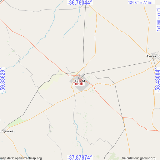
Tandil GPS coordinates[2]
37° 19' 18.012" South, 59° 7' 59.376" West
| Map corner | latitude | longitude |
|---|---|---|
| Upper-left | -36.76044°, | -59.83629° |
| Center: | -37.32167°, | -59.13316° |
| Lower-right: | -37.87874°, | -58.43004° |
| Map W x H: | 124.3×124.3 km | = 77.2×77.2mi |
| max Lat: | -21.94467° ⇑86.6% North |
| Tandil: | -37.32167° |
| min Lat: | ⇓13.4% South -54.81084° |
| min Long | Tandil | max Long |
| -72.88605° | -59.13316° | -53.64581° |
| W 74.7%⇐ | ⇒25.3% E |
Elevation
Elevation of Tandil is 192 m = 630 ft, and this is 157.3 m = 516 ft below average elevation for this country.
| Max E: |
4040 m = 13255 ft | 42.3% |
| Avg. | 349.3 m = 1146 ft | |
| Tandil | 192 m = 630 ft | |
Min E: |
-2 m = -7 ft | 57.7% |
See also: Tandil elevation on elevation.city.
Geographical zone
Tandil is located in South temperate zone (between Tropic of Capricorn and the Antarctic Circle). Distance of this Southern Tropic circle is 1543.9 km =959.3 mi to North.| Distance of | km | miles | from Tandil |
|---|---|---|---|
| Equator | 4149.8 | 2578.6 | to North |
| Tropic Capricorn | 1543.9 | 959.3 | to North |
| Antarctic Circle | 3251.4 | 2020.3 | to South |
| South Pole | 5857.3 | 3639.6 | to South |


Nearby cities:
15 places around Tandil: (largest is in red/bold)
• Ayacucho
60.2 km =37.4 mi,  71°
71°
• Azul
88.4 km =54.9 mi,  313°
313°
• Balcarce
96.9 km =60.2 mi,  127°
127°
• Benito Juárez
71 km =44.1 mi,  236°
236°
• Coronel Vidal
124.9 km =77.6 mi,  96°
96°
• General Guido
141.2 km =87.7 mi,  57°
57°
• Laprida
149.2 km =92.7 mi,  260°
260°
• Las Flores
145.4 km =90.3 mi,  1°
1°
• Lobería
97.5 km =60.6 mi,  162°
162°
• Maipú
122.2 km =75.9 mi, 65°
• Necochea
141.4 km =87.9 mi,  165°
165°
• Olavarría
115.7 km =71.9 mi,  294°
294°
• Rauch
61 km =37.9 mi, 3°
• San Cayetano
121.4 km =75.4 mi,  200°
200°
• Tapalqué
133.7 km =83.1 mi,  323°
323°
Sources, notices
• [Note1] Compared only with cities in Argentina existing in our database
• [Src1] Map data: © OpenStreetMap contributors (CC-BY-SA)
• [Src2] Other city data from geonames.org with taken over terms of usage.
• [Src3] Geographical zone / Annual Mean Temperature by Robert A. Rohde @ Wikipedia
