Esperanza geodata
Esperanza (Santa Fe) is a seat of a second-order administrative division; located in Argentina in America/Argentina/Cordoba (GMT-3) time zone. With population of 35,885 people, there are 117 cities with bigger population in this country. Compared to other cities in Argentina, 54.6% of cities are located further ↓South; 61.3% of cities are located further ←West and 85.8% of cities have higher elevation than Esperanza. Note1


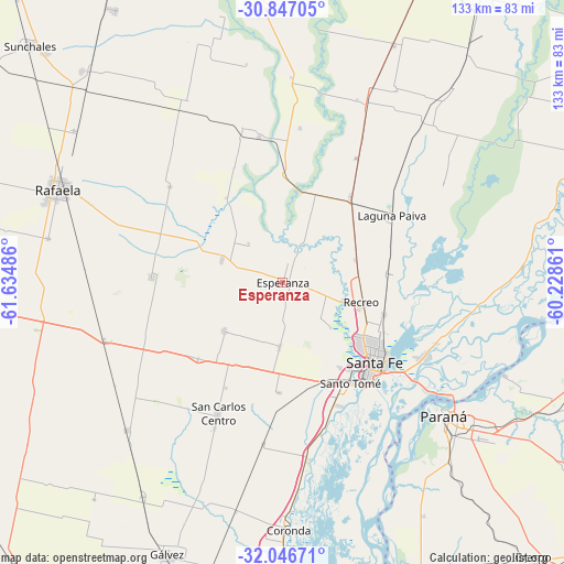
Esperanza GPS coordinates[2]
31° 26' 55.68" South, 60° 55' 54.228" West
| Map corner | latitude | longitude |
|---|---|---|
| Upper-left | -30.84705°, | -61.63486° |
| Center: | -31.4488°, | -60.93173° |
| Lower-right: | -32.04671°, | -60.22861° |
| Map W x H: | 133.4×133.4 km | = 82.9×82.9mi |
| max Lat: | -21.94467° ⇑45.4% North |
| Esperanza: | -31.4488° |
| min Lat: | ⇓54.6% South -54.81084° |
| min Long | Esperanza | max Long |
| -72.88605° | -60.93173° | -53.64581° |
| W 61.3%⇐ | ⇒38.7% E |
Elevation
Elevation of Esperanza is 40 m = 131 ft, and this is 309.3 m = 1015 ft below average elevation for this country.
| Max E: |
4040 m = 13255 ft | 85.8% |
| Avg. | 349.3 m = 1146 ft | |
| Esperanza | 40 m = 131 ft | |
Min E: |
-2 m = -7 ft | 14.2% |
See also: Argentina elevation on elevation.city.
Geographical zone
Esperanza is located in South temperate zone (between Tropic of Capricorn and the Antarctic Circle). Distance of this Southern Tropic circle is 890.9 km =553.6 mi to North.| Distance of | km | miles | from Esperanza |
|---|---|---|---|
| Equator | 3496.8 | 2172.8 | to North |
| Tropic Capricorn | 890.9 | 553.6 | to North |
| Antarctic Circle | 3904.4 | 2426.1 | to South |
| South Pole | 6510.3 | 4045.3 | to South |


Nearby cities:
15 places around Esperanza: (largest is in red/bold)
• Bella Italia
49.1 km =30.5 mi,  292°
292°
• Coronda
58.3 km =36.2 mi,  178°
178°
• Diamante
74.1 km =46 mi,  158°
158°
• Gálvez
70.1 km =43.6 mi,  202°
202°
• Laguna Paiva
30.5 km =19 mi,  58°
58°
• Oro Verde
57.3 km =35.6 mi,  136°
136°
• Paraná
49.5 km =30.8 mi,  129°
129°
• Rafaela
57.1 km =35.5 mi, 292°
• Recreo
19.4 km =12.1 mi,  103°
103°
• San Benito
59.5 km =37 mi, 128°
• San Carlos Centro
34.6 km =21.5 mi,  205°
205°
• San Justo
80.2 km =49.8 mi,  23°
23°
• Santa Fe
30.7 km =19.1 mi, 136°
• Santo Tomé
28.5 km =17.7 mi,  146°
146°
• Villa Urquiza
57.2 km =35.5 mi,  112°
112°
Sources, notices
• [Note1] Compared only with cities in Argentina existing in our database
• [Src1] Map data: © OpenStreetMap contributors (CC-BY-SA)
• [Src2] Other city data from geonames.org with taken over terms of usage.
• [Src3] Geographical zone / Annual Mean Temperature by Robert A. Rohde @ Wikipedia
