Recreo geodata
Recreo (Santa Fe) is a populated place; located in Argentina in America/Argentina/Cordoba (GMT-3) time zone. With population of 12,798 people, there are 246 cities with bigger population in this country. Compared to other cities in Argentina, 54.1% of cities are located further ↓South; 62.5% of cities are located further ←West and 93.1% of cities have higher elevation than Recreo. Note1


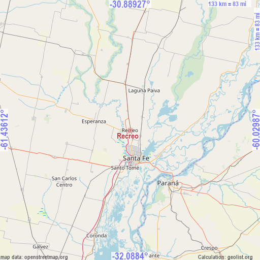
Recreo GPS coordinates[2]
31° 29' 26.736" South, 60° 43' 58.764" West
| Map corner | latitude | longitude |
|---|---|---|
| Upper-left | -30.88927°, | -61.43612° |
| Center: | -31.49076°, | -60.73299° |
| Lower-right: | -32.0884°, | -60.02987° |
| Map W x H: | 133.3×133.3 km | = 82.8×82.8mi |
| max Lat: | -21.94467° ⇑45.9% North |
| Recreo: | -31.49076° |
| min Lat: | ⇓54.1% South -54.81084° |
| min Long | Recreo | max Long |
| -72.88605° | -60.73299° | -53.64581° |
| W 62.5%⇐ | ⇒37.5% E |
Elevation
Elevation of Recreo is 23 m = 75 ft, and this is 326.3 m = 1071 ft below average elevation for this country.
| Max E: |
4040 m = 13255 ft | 93.1% |
| Avg. | 349.3 m = 1146 ft | |
| Recreo | 23 m = 75 ft | |
Min E: |
-2 m = -7 ft | 6.9% |
See also: Argentina elevation on elevation.city.
Geographical zone
Recreo is located in South temperate zone (between Tropic of Capricorn and the Antarctic Circle). Distance of this Southern Tropic circle is 895.5 km =556.4 mi to North.| Distance of | km | miles | from Recreo |
|---|---|---|---|
| Equator | 3501.4 | 2175.7 | to North |
| Tropic Capricorn | 895.5 | 556.4 | to North |
| Antarctic Circle | 3899.7 | 2423.2 | to South |
| South Pole | 6505.6 | 4042.4 | to South |


Nearby cities:
15 places around Recreo: (largest is in red/bold)
• Bella Italia
68.4 km =42.5 mi,  289°
289°
• Coronda
56.4 km =35 mi,  198°
198°
• Crespo
72.1 km =44.8 mi,  146°
146°
• Diamante
64.6 km =40.1 mi,  172°
172°
• Esperanza
19.4 km =12.1 mi,  283°
283°
• Gálvez
75.6 km =47 mi,  217°
217°
• Helvecia
75.2 km =46.7 mi,  54°
54°
• Laguna Paiva
21.9 km =13.6 mi,  18°
18°
• Oro Verde
42.4 km =26.3 mi, 151°
• Paraná
33.1 km =20.6 mi,  144°
144°
• San Benito
42.7 km =26.5 mi, 139°
• San Carlos Centro
43.1 km =26.8 mi,  232°
232°
• Santa Fe
17.7 km =11 mi, 172°
• Santo Tomé
19.4 km =12.1 mi,  189°
189°
• Villa Urquiza
38.1 km =23.7 mi,  117°
117°
Sources, notices
• [Note1] Compared only with cities in Argentina existing in our database
• [Src1] Map data: © OpenStreetMap contributors (CC-BY-SA)
• [Src2] Other city data from geonames.org with taken over terms of usage.
• [Src3] Geographical zone / Annual Mean Temperature by Robert A. Rohde @ Wikipedia
