Concarán geodata
Concarán (San Luis) is a seat of a second-order administrative division; located in Argentina in America/Argentina/San_Luis (GMT-3) time zone. With population of 4,530 people, there are 464 cities with bigger population in this country. Compared to other cities in Argentina, 57.1% of cities are located further ↑North; 74.6% of cities are located further →East and 84.7% of cities have lower elevation than Concarán. Note1


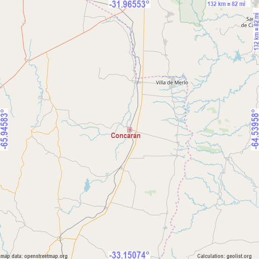
Concarán GPS coordinates[2]
32° 33' 36.324" South, 65° 14' 33.72" West
| Map corner | latitude | longitude |
|---|---|---|
| Upper-left | -31.96553°, | -65.94583° |
| Center: | -32.56009°, | -65.2427° |
| Lower-right: | -33.15074°, | -64.53958° |
| Map W x H: | 131.8×131.8 km | = 81.9×81.9mi |
| max Lat: | -21.94467° ⇑57.1% North |
| Concarán: | -32.56009° |
| min Lat: | ⇓42.9% South -54.81084° |
| min Long | Concarán | max Long |
| -72.88605° | -65.2427° | -53.64581° |
| W 25.4%⇐ | ⇒74.6% E |
Elevation
Elevation of Concarán is 673 m = 2208 ft, and this is 323.7 m = 1062 ft above average elevation for this country.
| Max E: |
4040 m = 13255 ft | 15.3% |
| Concarán | 673 m 2208 ft | |
| Avg. | 349.3 m = 1146 ft | |
Min E: |
-2 m = -7 ft | 84.7% |
See also: Argentina elevation on elevation.city.
Geographical zone
Concarán is located in South temperate zone (between Tropic of Capricorn and the Antarctic Circle). Distance of this Southern Tropic circle is 1014.4 km =630.3 mi to North.| Distance of | km | miles | from Concarán |
|---|---|---|---|
| Equator | 3620.3 | 2249.5 | to North |
| Tropic Capricorn | 1014.4 | 630.3 | to North |
| Antarctic Circle | 3780.8 | 2349.3 | to South |
| South Pole | 6386.7 | 3968.5 | to South |


Nearby cities:
15 places around Concarán: (largest is in red/bold)
• Achiras
72.3 km =44.9 mi,  161°
161°
• Berrotarán
81 km =50.3 mi,  81°
81°
• Candelaria
78 km =48.5 mi,  315°
315°
• Elena
79.5 km =49.4 mi,  90°
90°
• La Toma
65.3 km =40.6 mi,  213°
213°
• Libertador General San Martín
43.9 km =27.3 mi,  292°
292°
• Luján
68.5 km =42.6 mi, 288°
• Merlo
32.3 km =20.1 mi,  41°
41°
• Naschel
41.5 km =25.8 mi,  197°
197°
• San Francisco del Monte de Oro
82.8 km =51.4 mi,  267°
267°
• Santa Rosa del Conlara
24.4 km =15.2 mi,  8°
8°
• Tilisarao
19.7 km =12.2 mi,  193°
193°
• Villa Dolores
68.5 km =42.6 mi,  4°
4°
• Villa Las Rosas
70.1 km =43.6 mi, 14°
• Villa Rumipal
82.7 km =51.4 mi,  59°
59°
Sources, notices
• [Note1] Compared only with cities in Argentina existing in our database
• [Src1] Map data: © OpenStreetMap contributors (CC-BY-SA)
• [Src2] Other city data from geonames.org with taken over terms of usage.
• [Src3] Geographical zone / Annual Mean Temperature by Robert A. Rohde @ Wikipedia
