San Rafael geodata
San Rafael (Mendoza) is a seat of a second-order administrative division; located in Argentina in America/Argentina/Mendoza (GMT-3) time zone. With population of 109,163 people, there are 37 cities with bigger population in this country. Compared to other cities in Argentina, 73.7% of cities are located further ↑North; 91% of cities are located further →East and 85.3% of cities have lower elevation than San Rafael. Note1


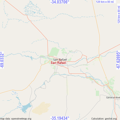
San Rafael GPS coordinates[2]
34° 37' 3.792" South, 68° 19' 48.252" West
| Map corner | latitude | longitude |
|---|---|---|
| Upper-left | -34.03706°, | -69.0332° |
| Center: | -34.61772°, | -68.33007° |
| Lower-right: | -35.19434°, | -67.62695° |
| Map W x H: | 128.7×128.7 km | = 80×80mi |
| max Lat: | -21.94467° ⇑73.7% North |
| San Rafael: | -34.61772° |
| min Lat: | ⇓26.3% South -54.81084° |
| min Long | San Rafael | max Long |
| -72.88605° | -68.33007° | -53.64581° |
| W 9%⇐ | ⇒91% E |
Elevation
Elevation of San Rafael is 702 m = 2303 ft, and this is 352.7 m = 1157 ft above average elevation for this country.
| Max E: |
4040 m = 13255 ft | 14.7% |
| San Rafael | 702 m 2303 ft | |
| Avg. | 349.3 m = 1146 ft | |
Min E: |
-2 m = -7 ft | 85.3% |
See also: San Rafael elevation on elevation.city.
Geographical zone
San Rafael is located in South temperate zone (between Tropic of Capricorn and the Antarctic Circle). Distance of this Southern Tropic circle is 1243.2 km =772.5 mi to North.| Distance of | km | miles | from San Rafael |
|---|---|---|---|
| Equator | 3849.1 | 2391.7 | to North |
| Tropic Capricorn | 1243.2 | 772.5 | to North |
| Antarctic Circle | 3552 | 2207.1 | to South |
| South Pole | 6157.9 | 3826.3 | to South |


Nearby cities:
15 places around San Rafael: (largest is in red/bold)
• General Alvear
70.7 km =43.9 mi,  124°
124°
• Godoy Cruz
193.5 km =120.2 mi,  346°
346°
• Junín
164 km =101.9 mi,  355°
355°
• La Consulta
122.1 km =75.9 mi,  323°
323°
• La Humada
194.6 km =120.9 mi,  171°
171°
• La Paz
147.4 km =91.6 mi,  29°
29°
• Luján de Cuyo
183.1 km =113.8 mi,  343°
343°
• Maipú
186.9 km =116.1 mi, 347°
• Malargüe
148.8 km =92.5 mi,  230°
230°
• Rivadavia
159.1 km =98.9 mi, 355°
• San Martín
171.3 km =106.4 mi, 355°
• Santa Rosa
152.5 km =94.8 mi,  6°
6°
• Tunuyán
131.8 km =81.9 mi,  331°
331°
• Tupungato
157.8 km =98.1 mi, 331°
• Villa Nueva
195.8 km =121.7 mi, 347°
Sources, notices
• [Note1] Compared only with cities in Argentina existing in our database
• [Src1] Map data: © OpenStreetMap contributors (CC-BY-SA)
• [Src2] Other city data from geonames.org with taken over terms of usage.
• [Src3] Geographical zone / Annual Mean Temperature by Robert A. Rohde @ Wikipedia
