Tres Arroyos geodata
Tres Arroyos (Buenos Aires) is a seat of a second-order administrative division; located in Argentina in America/Argentina/Buenos_Aires (GMT-3) time zone. With population of 47,136 people, there are 95 cities with bigger population in this country. Compared to other cities in Argentina, 89.7% of cities are located further ↑North; 66% of cities are located further ←West and 58.1% of cities have higher elevation than Tres Arroyos. Note1


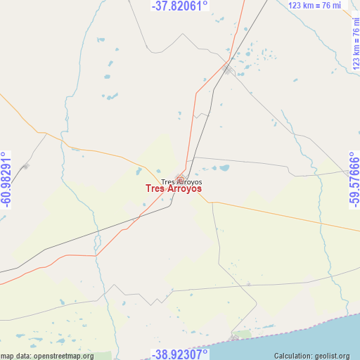
Tres Arroyos GPS coordinates[2]
38° 22' 26.184" South, 60° 16' 47.208" West
| Map corner | latitude | longitude |
|---|---|---|
| Upper-left | -37.82061°, | -60.98291° |
| Center: | -38.37394°, | -60.27978° |
| Lower-right: | -38.92307°, | -59.57666° |
| Map W x H: | 122.6×122.6 km | = 76.2×76.2mi |
| max Lat: | -21.94467° ⇑89.7% North |
| Tres Arroyos: | -38.37394° |
| min Lat: | ⇓10.3% South -54.81084° |
| min Long | Tres Arroyos | max Long |
| -72.88605° | -60.27978° | -53.64581° |
| W 66%⇐ | ⇒34% E |
Elevation
Elevation of Tres Arroyos is 113 m = 371 ft, and this is 236.3 m = 775 ft below average elevation for this country.
| Max E: |
4040 m = 13255 ft | 58.1% |
| Avg. | 349.3 m = 1146 ft | |
| Tres Arroyos | 113 m = 371 ft | |
Min E: |
-2 m = -7 ft | 41.9% |
See also: Tres Arroyos elevation on elevation.city.
Geographical zone
Tres Arroyos is located in South temperate zone (between Tropic of Capricorn and the Antarctic Circle). Distance of this Southern Tropic circle is 1660.9 km =1032 mi to North.| Distance of | km | miles | from Tres Arroyos |
|---|---|---|---|
| Equator | 4266.8 | 2651.3 | to North |
| Tropic Capricorn | 1660.9 | 1032 | to North |
| Antarctic Circle | 3134.4 | 1947.6 | to South |
| South Pole | 5740.3 | 3566.9 | to South |


Nearby cities:
15 places around Tres Arroyos: (largest is in red/bold)
• Bahía Blanca
177.5 km =110.3 mi,  257°
257°
• Benito Juárez
88.4 km =54.9 mi,  27°
27°
• Coronel Dorrego
95.6 km =59.4 mi,  246°
246°
• Coronel Pringles
103.6 km =64.4 mi,  294°
294°
• Coronel Suárez
177.4 km =110.2 mi,  305°
305°
• General La Madrid
152.1 km =94.5 mi,  325°
325°
• Laprida
102.9 km =63.9 mi, 333°
• Lobería
132.2 km =82.1 mi,  79°
79°
• Monte Hermoso
111.1 km =69 mi,  232°
232°
• Necochea
135.6 km =84.3 mi,  98°
98°
• Olavarría
164.7 km =102.3 mi,  358°
358°
• Punta Alta
165.5 km =102.8 mi, 250°
• San Cayetano
58.5 km =36.4 mi,  87°
87°
• Tandil
154.3 km =95.9 mi,  40°
40°
• Tornquist
172.4 km =107.1 mi,  280°
280°
Sources, notices
• [Note1] Compared only with cities in Argentina existing in our database
• [Src1] Map data: © OpenStreetMap contributors (CC-BY-SA)
• [Src2] Other city data from geonames.org with taken over terms of usage.
• [Src3] Geographical zone / Annual Mean Temperature by Robert A. Rohde @ Wikipedia
