San Luis geodata
San Luis is a seat of a first-order administrative division; located in Argentina in America/Argentina/San_Luis (GMT-3) time zone. With population of 183,982 people, there are 25 cities with bigger population in this country. Compared to other cities in Argentina, 65.2% of cities are located further ↑North; 84.3% of cities are located further →East and 86.4% of cities have lower elevation than San Luis. Note1


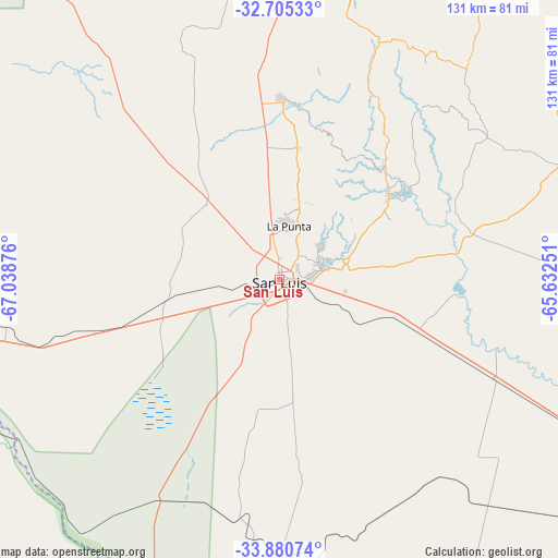
San Luis GPS coordinates[2]
33° 17' 42.036" South, 66° 20' 8.268" West
| Map corner | latitude | longitude |
|---|---|---|
| Upper-left | -32.70533°, | -67.03876° |
| Center: | -33.29501°, | -66.33563° |
| Lower-right: | -33.88074°, | -65.63251° |
| Map W x H: | 130.7×130.7 km | = 81.2×81.2mi |
| max Lat: | -21.94467° ⇑65.2% North |
| San Luis: | -33.29501° |
| min Lat: | ⇓34.8% South -54.81084° |
| min Long | San Luis | max Long |
| -72.88605° | -66.33563° | -53.64581° |
| W 15.7%⇐ | ⇒84.3% E |
Elevation
Elevation of San Luis is 729 m = 2392 ft, and this is 379.7 m = 1246 ft above average elevation for this country.
| Max E: |
4040 m = 13255 ft | 13.6% |
| San Luis | 729 m 2392 ft | |
| Avg. | 349.3 m = 1146 ft | |
Min E: |
-2 m = -7 ft | 86.4% |
See also: San Luis elevation on elevation.city.
Geographical zone
San Luis is located in South temperate zone (between Tropic of Capricorn and the Antarctic Circle). Distance of this Southern Tropic circle is 1096.1 km =681.1 mi to North.| Distance of | km | miles | from San Luis |
|---|---|---|---|
| Equator | 3702.1 | 2300.4 | to North |
| Tropic Capricorn | 1096.1 | 681.1 | to North |
| Antarctic Circle | 3699.1 | 2298.5 | to South |
| South Pole | 6305 | 3917.7 | to South |


Nearby cities:
15 places around San Luis: (largest is in red/bold)
• Achiras
125.5 km =78 mi,  83°
83°
• Candelaria
145.4 km =90.3 mi,  19°
19°
• Concarán
130.7 km =81.2 mi,  51°
51°
• Justo Daract
123.9 km =77 mi,  120°
120°
• La Paz
114.2 km =71 mi,  260°
260°
• La Punta
12.6 km =7.8 mi,  9°
9°
• La Toma
71.5 km =44.4 mi,  67°
67°
• Libertador General San Martín
116 km =72.1 mi,  32°
32°
• Luján
109.7 km =68.2 mi, 19°
• Naschel
98.8 km =61.4 mi,  64°
64°
• San Francisco del Monte de Oro
79.9 km =49.6 mi, 14°
• Santa Rosa del Conlara
149.7 km =93 mi,  44°
44°
• Tilisarao
115.7 km =71.9 mi, 57°
• Villa General Roca
70.8 km =44 mi,  351°
351°
• Villa Mercedes
91.8 km =57 mi, 117°
Sources, notices
• [Note1] Compared only with cities in Argentina existing in our database
• [Src1] Map data: © OpenStreetMap contributors (CC-BY-SA)
• [Src2] Other city data from geonames.org with taken over terms of usage.
• [Src3] Geographical zone / Annual Mean Temperature by Robert A. Rohde @ Wikipedia
