Villa General Roca geodata
Villa General Roca (San Luis) is a seat of a second-order administrative division; located in Argentina in America/Argentina/San_Luis (GMT-3) time zone. With population of 196 people, there are 784 cities with bigger population in this country. Compared to other cities in Argentina, 58.1% of cities are located further ↑North; 84.5% of cities are located further →East and 83.7% of cities have lower elevation than Villa General Roca. Note1


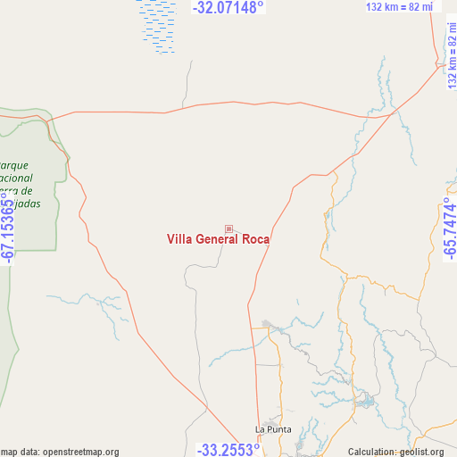
Villa General Roca GPS coordinates[2]
32° 39' 55.26" South, 66° 27' 1.872" West
| Map corner | latitude | longitude |
|---|---|---|
| Upper-left | -32.07148°, | -67.15365° |
| Center: | -32.66535°, | -66.45052° |
| Lower-right: | -33.2553°, | -65.7474° |
| Map W x H: | 131.6×131.6 km | = 81.8×81.8mi |
| max Lat: | -21.94467° ⇑58.1% North |
| Villa General Roca: | -32.66535° |
| min Lat: | ⇓41.9% South -54.81084° |
| min Long | Villa General R | max Long |
| -72.88605° | -66.45052° | -53.64581° |
| W 15.5%⇐ | ⇒84.5% E |
Elevation
Elevation of Villa General Roca is 650 m = 2133 ft, and this is 300.7 m = 987 ft above average elevation for this country.
| Max E: |
4040 m = 13255 ft | 16.3% |
| Villa General Roca | 650 m 2133 ft | |
| Avg. | 349.3 m = 1146 ft | |
Min E: |
-2 m = -7 ft | 83.7% |
See also: Argentina elevation on elevation.city.
Geographical zone
Villa General Roca is located in South temperate zone (between Tropic of Capricorn and the Antarctic Circle). Distance of this Southern Tropic circle is 1026.1 km =637.6 mi to North.| Distance of | km | miles | from Villa General Roca |
|---|---|---|---|
| Equator | 3632 | 2256.8 | to North |
| Tropic Capricorn | 1026.1 | 637.6 | to North |
| Antarctic Circle | 3769.1 | 2342 | to South |
| South Pole | 6375 | 3961.2 | to South |


Nearby cities:
15 places around Villa General Roca: (largest is in red/bold)
• Candelaria
89.3 km =55.5 mi,  41°
41°
• Concarán
113.7 km =70.6 mi,  84°
84°
• La Paz
135.3 km =84.1 mi,  229°
229°
• La Punta
59.1 km =36.7 mi,  167°
167°
• La Toma
88.4 km =54.9 mi,  119°
119°
• Libertador General San Martín
77.9 km =48.4 mi,  68°
68°
• Luján
58.5 km =36.4 mi,  55°
55°
• Merlo
139.4 km =86.6 mi, 75°
• Naschel
104.3 km =64.8 mi,  105°
105°
• San Francisco del Monte de Oro
31.3 km =19.4 mi, 76°
• San Luis
70.8 km =44 mi, 171°
• Santa Rosa del Conlara
122.3 km =76 mi, 72°
• Tilisarao
108.7 km =67.5 mi,  93°
93°
• Ulapes
123.1 km =76.5 mi,  9°
9°
• Villa Dolores
143 km =88.9 mi, 55°
Sources, notices
• [Note1] Compared only with cities in Argentina existing in our database
• [Src1] Map data: © OpenStreetMap contributors (CC-BY-SA)
• [Src2] Other city data from geonames.org with taken over terms of usage.
• [Src3] Geographical zone / Annual Mean Temperature by Robert A. Rohde @ Wikipedia
