La Punta geodata
La Punta (San Luis) is a populated locality; located in Argentina in America/Argentina/San_Luis (GMT-3) time zone. With population of 15,000 people, there are 226 cities with bigger population in this country. Compared to other cities in Argentina, 64.3% of cities are located further ↑North; 83.9% of cities are located further →East and 88.7% of cities have lower elevation than La Punta. Note1


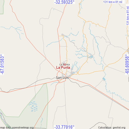
La Punta GPS coordinates[2]
33° 11' 1.248" South, 66° 18' 45.72" West
| Map corner | latitude | longitude |
|---|---|---|
| Upper-left | -32.59325°, | -67.01583° |
| Center: | -33.18368°, | -66.3127° |
| Lower-right: | -33.77016°, | -65.60958° |
| Map W x H: | 130.9×130.9 km | = 81.3×81.3mi |
| max Lat: | -21.94467° ⇑64.3% North |
| La Punta: | -33.18368° |
| min Lat: | ⇓35.7% South -54.81084° |
| min Long | La Punta | max Long |
| -72.88605° | -66.3127° | -53.64581° |
| W 16.1%⇐ | ⇒83.9% E |
Elevation
Elevation of La Punta is 814 m = 2671 ft, and this is 464.7 m = 1525 ft above average elevation for this country.
| Max E: |
4040 m = 13255 ft | 11.3% |
| La Punta | 814 m 2671 ft | |
| Avg. | 349.3 m = 1146 ft | |
Min E: |
-2 m = -7 ft | 88.7% |
See also: Argentina elevation on elevation.city.
Geographical zone
La Punta is located in South temperate zone (between Tropic of Capricorn and the Antarctic Circle). Distance of this Southern Tropic circle is 1083.8 km =673.4 mi to North.| Distance of | km | miles | from La Punta |
|---|---|---|---|
| Equator | 3689.7 | 2292.7 | to North |
| Tropic Capricorn | 1083.8 | 673.4 | to North |
| Antarctic Circle | 3711.5 | 2306.2 | to South |
| South Pole | 6317.4 | 3925.4 | to South |


Nearby cities:
15 places around La Punta: (largest is in red/bold)
• Achiras
122.8 km =76.3 mi,  89°
89°
• Candelaria
133 km =82.6 mi,  20°
20°
• Concarán
121.6 km =75.6 mi,  55°
55°
• Justo Daract
128.9 km =80.1 mi,  125°
125°
• La Paz
119 km =73.9 mi,  254°
254°
• La Toma
65.8 km =40.9 mi,  77°
77°
• Libertador General San Martín
104.5 km =64.9 mi,  34°
34°
• Luján
97.4 km =60.5 mi, 21°
• Naschel
92.3 km =57.4 mi,  71°
71°
• San Francisco del Monte de Oro
67.4 km =41.9 mi, 15°
• San Luis
12.6 km =7.8 mi,  189°
189°
• Santa Rosa del Conlara
139.6 km =86.7 mi,  47°
47°
• Tilisarao
107.7 km =66.9 mi, 62°
• Villa General Roca
59.1 km =36.7 mi,  347°
347°
• Villa Mercedes
96.4 km =59.9 mi,  124°
124°
Sources, notices
• [Note1] Compared only with cities in Argentina existing in our database
• [Src1] Map data: © OpenStreetMap contributors (CC-BY-SA)
• [Src2] Other city data from geonames.org with taken over terms of usage.
• [Src3] Geographical zone / Annual Mean Temperature by Robert A. Rohde @ Wikipedia
