Gobernador Gálvez geodata
Gobernador Gálvez (Santa Fe) is a populated place; located in Argentina in America/Argentina/Cordoba (GMT-3) time zone. With population of 74,650 people, there are 58 cities with bigger population in this country. Compared to other cities in Argentina, 62.3% of cities are located further ↑North; 63.5% of cities are located further ←West and 90.3% of cities have higher elevation than Gobernador Gálvez. Note1


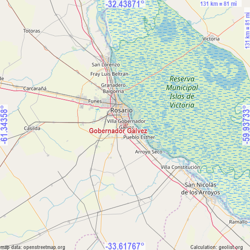
Gobernador Gálvez GPS coordinates[2]
33° 1' 48.576" South, 60° 38' 25.62" West
| Map corner | latitude | longitude |
|---|---|---|
| Upper-left | -32.43871°, | -61.34358° |
| Center: | -33.03016°, | -60.64045° |
| Lower-right: | -33.61767°, | -59.93733° |
| Map W x H: | 131.1×131.1 km | = 81.5×81.5mi |
| max Lat: | -21.94467° ⇑62.3% North |
| Gobernador Gálvez: | -33.03016° |
| min Lat: | ⇓37.7% South -54.81084° |
| min Long | Gobernador Gál | max Long |
| -72.88605° | -60.64045° | -53.64581° |
| W 63.5%⇐ | ⇒36.5% E |
Elevation
Elevation of Gobernador Gálvez is 28 m = 92 ft, and this is 321.3 m = 1054 ft below average elevation for this country.
| Max E: |
4040 m = 13255 ft | 90.3% |
| Avg. | 349.3 m = 1146 ft | |
| Gobernador Gálvez | 28 m = 92 ft | |
Min E: |
-2 m = -7 ft | 9.7% |
See also: Gobernador Gálvez elevation on elevation.city.
Geographical zone
Gobernador Gálvez is located in South temperate zone (between Tropic of Capricorn and the Antarctic Circle). Distance of this Southern Tropic circle is 1066.7 km =662.8 mi to North.| Distance of | km | miles | from Gobernador Gálvez |
|---|---|---|---|
| Equator | 3672.6 | 2282 | to North |
| Tropic Capricorn | 1066.7 | 662.8 | to North |
| Antarctic Circle | 3728.6 | 2316.8 | to South |
| South Pole | 6334.5 | 3936.1 | to South |


Nearby cities:
15 places around Gobernador Gálvez: (largest is in red/bold)
• Arroyo Seco
18.5 km =11.5 mi,  138°
138°
• Capitán Bermúdez
24.2 km =15 mi,  342°
342°
• Carcarañá
51.6 km =32.1 mi,  291°
291°
• Casilda
49.2 km =30.6 mi,  268°
268°
• Fray Luis A. Beltrán
27.8 km =17.3 mi, 342°
• Funes
20.3 km =12.6 mi,  308°
308°
• Granadero Baigorria
20.6 km =12.8 mi, 339°
• Pérez
12.4 km =7.7 mi, 286°
• Roldán
28.8 km =17.9 mi,  300°
300°
• Rosario
9.3 km =5.8 mi,  0°
0°
• San Lorenzo
33.1 km =20.6 mi, 344°
• San Nicolás de los Arroyos
52.4 km =32.6 mi,  130°
130°
• Victoria
64.5 km =40.1 mi,  44°
44°
• Villa Constitución
36.3 km =22.6 mi, 127°
• Villa Mugueta
49.7 km =30.9 mi,  230°
230°
Sources, notices
• [Note1] Compared only with cities in Argentina existing in our database
• [Src1] Map data: © OpenStreetMap contributors (CC-BY-SA)
• [Src2] Other city data from geonames.org with taken over terms of usage.
• [Src3] Geographical zone / Annual Mean Temperature by Robert A. Rohde @ Wikipedia
