Pérez geodata
Pérez (Santa Fe) is a populated place; located in Argentina in America/Argentina/Cordoba (GMT-3) time zone. With population of 24,436 people, there are 166 cities with bigger population in this country. Compared to other cities in Argentina, 61.9% of cities are located further ↑North; 62.1% of cities are located further ←West and 86.5% of cities have higher elevation than Pérez. Note1


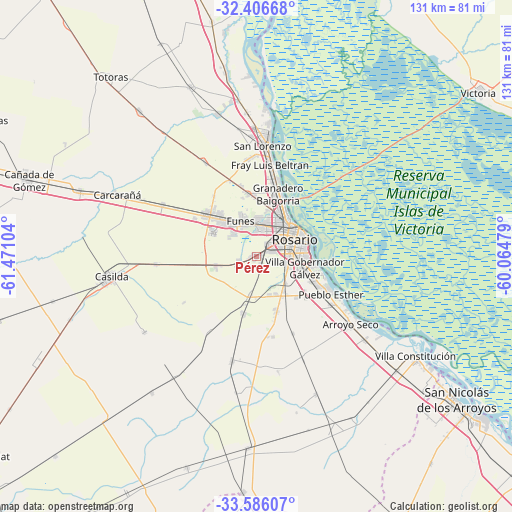
Pérez GPS coordinates[2]
32° 59' 54.06" South, 60° 46' 4.476" West
| Map corner | latitude | longitude |
|---|---|---|
| Upper-left | -32.40668°, | -61.47104° |
| Center: | -32.99835°, | -60.76791° |
| Lower-right: | -33.58607°, | -60.06479° |
| Map W x H: | 131.1×131.1 km | = 81.5×81.5mi |
| max Lat: | -21.94467° ⇑61.9% North |
| Pérez: | -32.99835° |
| min Lat: | ⇓38.1% South -54.81084° |
| min Long | Pérez | max Long |
| -72.88605° | -60.76791° | -53.64581° |
| W 62.1%⇐ | ⇒37.9% E |
Elevation
Elevation of Pérez is 37 m = 121 ft, and this is 312.3 m = 1025 ft below average elevation for this country.
| Max E: |
4040 m = 13255 ft | 86.5% |
| Avg. | 349.3 m = 1146 ft | |
| Pérez | 37 m = 121 ft | |
Min E: |
-2 m = -7 ft | 13.5% |
See also: Argentina elevation on elevation.city.
Geographical zone
Pérez is located in South temperate zone (between Tropic of Capricorn and the Antarctic Circle). Distance of this Southern Tropic circle is 1063.2 km =660.6 mi to North.| Distance of | km | miles | from Pérez |
|---|---|---|---|
| Equator | 3669.1 | 2279.9 | to North |
| Tropic Capricorn | 1063.2 | 660.6 | to North |
| Antarctic Circle | 3732.1 | 2319 | to South |
| South Pole | 6338 | 3938.2 | to South |


Nearby cities:
15 places around Pérez: (largest is in red/bold)
• Arroyo Seco
29.8 km =18.5 mi,  125°
125°
• Capitán Bermúdez
20.1 km =12.5 mi,  13°
13°
• Carcarañá
39.3 km =24.4 mi,  293°
293°
• Casilda
37.7 km =23.4 mi,  262°
262°
• Cañada de Gómez
61.9 km =38.5 mi, 289°
• Fray Luis A. Beltrán
23.3 km =14.5 mi, 9°
• Funes
10 km =6.2 mi,  336°
336°
• Gobernador Gálvez
12.4 km =7.7 mi,  106°
106°
• Granadero Baigorria
16.4 km =10.2 mi,  16°
16°
• Roldán
17.1 km =10.6 mi,  310°
310°
• Rosario
13.3 km =8.3 mi,  64°
64°
• San Lorenzo
28.5 km =17.7 mi, 5°
• Totoras
59.3 km =36.8 mi,  320°
320°
• Villa Constitución
48.1 km =29.9 mi,  122°
122°
• Villa Mugueta
43.9 km =27.3 mi,  217°
217°
Sources, notices
• [Note1] Compared only with cities in Argentina existing in our database
• [Src1] Map data: © OpenStreetMap contributors (CC-BY-SA)
• [Src2] Other city data from geonames.org with taken over terms of usage.
• [Src3] Geographical zone / Annual Mean Temperature by Robert A. Rohde @ Wikipedia
