Gualeguay geodata
Gualeguay (Entre Rios) is a seat of a second-order administrative division; located in Argentina in America/Argentina/Cordoba (GMT-3) time zone. With population of 33,120 people, there are 124 cities with bigger population in this country. Compared to other cities in Argentina, 63.6% of cities are located further ↑North; 73.7% of cities are located further ←West and 96.8% of cities have higher elevation than Gualeguay. Note1


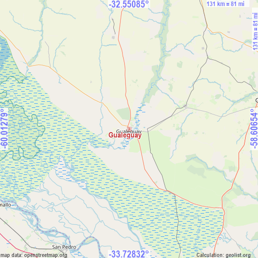
Gualeguay GPS coordinates[2]
33° 8' 29.616" South, 59° 18' 34.776" West
| Map corner | latitude | longitude |
|---|---|---|
| Upper-left | -32.55085°, | -60.01279° |
| Center: | -33.14156°, | -59.30966° |
| Lower-right: | -33.72832°, | -58.60654° |
| Map W x H: | 130.9×130.9 km | = 81.3×81.3mi |
| max Lat: | -21.94467° ⇑63.6% North |
| Gualeguay: | -33.14156° |
| min Lat: | ⇓36.4% South -54.81084° |
| min Long | Gualeguay | max Long |
| -72.88605° | -59.30966° | -53.64581° |
| W 73.7%⇐ | ⇒26.3% E |
Elevation
Elevation of Gualeguay is 14 m = 46 ft, and this is 335.3 m = 1100 ft below average elevation for this country.
| Max E: |
4040 m = 13255 ft | 96.8% |
| Avg. | 349.3 m = 1146 ft | |
| Gualeguay | 14 m = 46 ft | |
Min E: |
-2 m = -7 ft | 3.2% |
See also: Argentina elevation on elevation.city.
Geographical zone
Gualeguay is located in South temperate zone (between Tropic of Capricorn and the Antarctic Circle). Distance of this Southern Tropic circle is 1079.1 km =670.5 mi to North.| Distance of | km | miles | from Gualeguay |
|---|---|---|---|
| Equator | 3685 | 2289.8 | to North |
| Tropic Capricorn | 1079.1 | 670.5 | to North |
| Antarctic Circle | 3716.2 | 2309.1 | to South |
| South Pole | 6322.1 | 3928.4 | to South |


Nearby cities:
15 places around Gualeguay: (largest is in red/bold)
• Aldea San Antonio
80.7 km =50.1 mi,  44°
44°
• Baradero
76.7 km =47.7 mi,  193°
193°
• Ceibas
61.3 km =38.1 mi,  121°
121°
• General Galarza
47.5 km =29.5 mi,  350°
350°
• Gilbert
76.1 km =47.3 mi,  27°
27°
• Gobernador Mansilla
66.5 km =41.3 mi,  356°
356°
• Gualeguaychú
75.3 km =46.8 mi,  78°
78°
• Larroque
31 km =19.3 mi,  67°
67°
• Lucas González
86.7 km =53.9 mi, 346°
• Puerto Ibicuy
69.1 km =42.9 mi,  169°
169°
• Ramallo
75.2 km =46.7 mi,  239°
239°
• San Nicolás de los Arroyos
86.5 km =53.7 mi,  255°
255°
• San Pedro
68.3 km =42.4 mi,  208°
208°
• Urdinarrain
63.9 km =39.7 mi, 37°
• Villa Paranacito
87.8 km =54.6 mi,  136°
136°
Sources, notices
• [Note1] Compared only with cities in Argentina existing in our database
• [Src1] Map data: © OpenStreetMap contributors (CC-BY-SA)
• [Src2] Other city data from geonames.org with taken over terms of usage.
• [Src3] Geographical zone / Annual Mean Temperature by Robert A. Rohde @ Wikipedia
