Florentino Ameghino geodata
Florentino Ameghino (Buenos Aires) is a seat of a second-order administrative division; located in Argentina in America/Argentina/Buenos_Aires (GMT-3) time zone. In our database, there are 785 cities with bigger population. Compared to other cities in Argentina, 76.4% of cities are located further ↑North; 52.1% of cities are located further ←West and 57% of cities have higher elevation than Florentino Ameghino. Note1


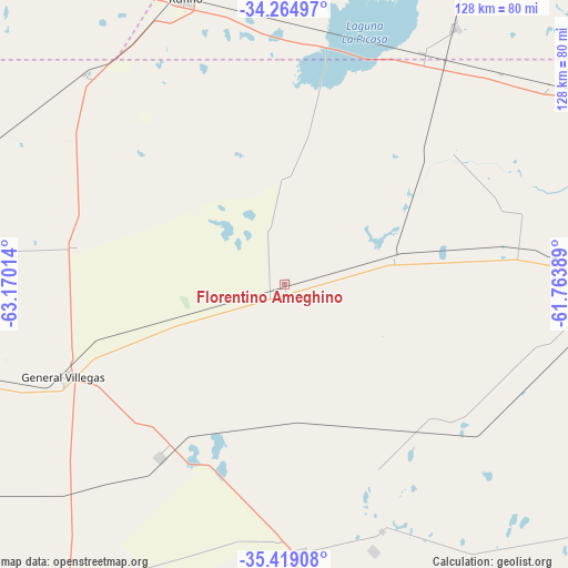
Florentino Ameghino GPS coordinates[2]
34° 50' 38.58" South, 62° 28' 1.236" West
| Map corner | latitude | longitude |
|---|---|---|
| Upper-left | -34.26497°, | -63.17014° |
| Center: | -34.84405°, | -62.46701° |
| Lower-right: | -35.41908°, | -61.76389° |
| Map W x H: | 128.3×128.3 km | = 79.7×79.7mi |
| max Lat: | -21.94467° ⇑76.4% North |
| Florentino Ameghino: | -34.84405° |
| min Lat: | ⇓23.6% South -54.81084° |
| min Long | Florentino Ameg | max Long |
| -72.88605° | -62.46701° | -53.64581° |
| W 52.1%⇐ | ⇒47.9% E |
Elevation
Elevation of Florentino Ameghino is 116 m = 381 ft, and this is 233.3 m = 765 ft below average elevation for this country.
| Max E: |
4040 m = 13255 ft | 57% |
| Avg. | 349.3 m = 1146 ft | |
| Florentino Ameghino | 116 m = 381 ft | |
Min E: |
-2 m = -7 ft | 43% |
See also: Argentina elevation on elevation.city.
Geographical zone
Florentino Ameghino is located in South temperate zone (between Tropic of Capricorn and the Antarctic Circle). Distance of this Southern Tropic circle is 1268.4 km =788.1 mi to North.| Distance of | km | miles | from Florentino Ameghino |
|---|---|---|---|
| Equator | 3874.3 | 2407.4 | to North |
| Tropic Capricorn | 1268.4 | 788.1 | to North |
| Antarctic Circle | 3526.9 | 2191.5 | to South |
| South Pole | 6132.8 | 3810.7 | to South |


Nearby cities:
15 places around Florentino Ameghino: (largest is in red/bold)
• Bernardo Larroudé
103.6 km =64.4 mi,  258°
258°
• Buchardo
96.1 km =59.7 mi,  278°
278°
• Carlos Tejedor
61.1 km =38 mi,  176°
176°
• General Pinto
53.3 km =33.1 mi,  80°
80°
• General Villegas
54 km =33.6 mi,  247°
247°
• Intendente Alvear
111.2 km =69.1 mi, 247°
• Italó
120.2 km =74.7 mi,  272°
272°
• La Cesira
109.6 km =68.1 mi,  334°
334°
• Laboulaye
116.4 km =72.3 mi,  313°
313°
• Lincoln
85.5 km =53.1 mi,  91°
91°
• Pehuajó
119.3 km =74.1 mi,  154°
154°
• Rufino
67.9 km =42.2 mi,  340°
340°
• Serrano
106.5 km =66.2 mi,  293°
293°
• Tres Algarrobos
48 km =29.8 mi,  215°
215°
• Vedia
93.1 km =57.8 mi,  65°
65°
Sources, notices
• [Note1] Compared only with cities in Argentina existing in our database
• [Src1] Map data: © OpenStreetMap contributors (CC-BY-SA)
• [Src2] Other city data from geonames.org with taken over terms of usage.
• [Src3] Geographical zone / Annual Mean Temperature by Robert A. Rohde @ Wikipedia
