Daireaux geodata
Daireaux (Buenos Aires) is a seat of a second-order administrative division; located in Argentina in America/Argentina/Buenos_Aires (GMT-3) time zone. In our database, there are 785 cities with bigger population. Compared to other cities in Argentina, 84% of cities are located further ↑North; 56.7% of cities are located further ←West and 56.4% of cities have higher elevation than Daireaux. Note1


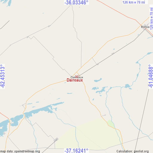
Daireaux GPS coordinates[2]
36° 36' 0" South, 61° 45' 0" West
| Map corner | latitude | longitude |
|---|---|---|
| Upper-left | -36.03346°, | -62.45313° |
| Center: | -36.6°, | -61.75° |
| Lower-right: | -37.16241°, | -61.04688° |
| Map W x H: | 125.5×125.5 km | = 78×78mi |
| max Lat: | -21.94467° ⇑84% North |
| Daireaux: | -36.6° |
| min Lat: | ⇓16% South -54.81084° |
| min Long | Daireaux | max Long |
| -72.88605° | -61.75° | -53.64581° |
| W 56.7%⇐ | ⇒43.3% E |
Elevation
Elevation of Daireaux is 118 m = 387 ft, and this is 231.3 m = 759 ft below average elevation for this country.
| Max E: |
4040 m = 13255 ft | 56.4% |
| Avg. | 349.3 m = 1146 ft | |
| Daireaux | 118 m = 387 ft | |
Min E: |
-2 m = -7 ft | 43.6% |
See also: Argentina elevation on elevation.city.
Geographical zone
Daireaux is located in South temperate zone (between Tropic of Capricorn and the Antarctic Circle). Distance of this Southern Tropic circle is 1463.6 km =909.4 mi to North.| Distance of | km | miles | from Daireaux |
|---|---|---|---|
| Equator | 4069.5 | 2528.7 | to North |
| Tropic Capricorn | 1463.6 | 909.4 | to North |
| Antarctic Circle | 3331.6 | 2070.2 | to South |
| South Pole | 5937.5 | 3689.4 | to South |


Nearby cities:
15 places around Daireaux: (largest is in red/bold)
• Carhué
110.2 km =68.5 mi,  234°
234°
• Carlos Casares
114.2 km =71 mi,  17°
17°
• Coronel Suárez
96.4 km =59.9 mi,  189°
189°
• General La Madrid
84 km =52.2 mi,  148°
148°
• Guaminí
75.2 km =46.7 mi, 232°
• Henderson
33.5 km =20.8 mi,  5°
5°
• Laprida
134.6 km =83.6 mi,  141°
141°
• Olavarría
131.3 km =81.6 mi,  104°
104°
• Pehuajó
88.7 km =55.1 mi,  351°
351°
• Pellegrini
132 km =82 mi,  286°
286°
• Pigüé
125.9 km =78.2 mi,  207°
207°
• Salliqueló
109.3 km =67.9 mi,  261°
261°
• San Carlos de Bolívar
70.1 km =43.6 mi,  54°
54°
• Trenque Lauquen
112.6 km =70 mi,  308°
308°
• Tres Lomas
100.5 km =62.4 mi,  279°
279°
Sources, notices
• [Note1] Compared only with cities in Argentina existing in our database
• [Src1] Map data: © OpenStreetMap contributors (CC-BY-SA)
• [Src2] Other city data from geonames.org with taken over terms of usage.
• [Src3] Geographical zone / Annual Mean Temperature by Robert A. Rohde @ Wikipedia
