Malargüe geodata
Malargüe (Mendoza) is a seat of a second-order administrative division; located in Argentina in America/Argentina/Mendoza (GMT-3) time zone. In our database, there are 785 cities with bigger population. Compared to other cities in Argentina, 80% of cities are located further ↑North; 95.9% of cities are located further →East and 96.6% of cities have lower elevation than Malargüe. Note1


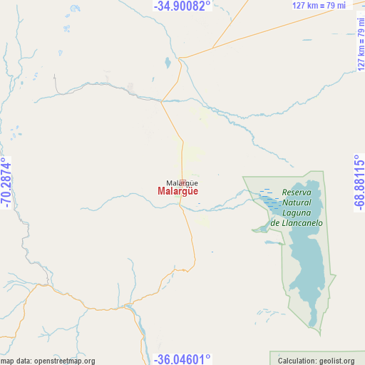
Malargüe GPS coordinates[2]
35° 28' 31.62" South, 69° 35' 3.372" West
| Map corner | latitude | longitude |
|---|---|---|
| Upper-left | -34.90082°, | -70.2874° |
| Center: | -35.47545°, | -69.58427° |
| Lower-right: | -36.04601°, | -68.88115° |
| Map W x H: | 127.3×127.3 km | = 79.1×79.1mi |
| max Lat: | -21.94467° ⇑80% North |
| Malargüe: | -35.47545° |
| min Lat: | ⇓20% South -54.81084° |
| min Long | Malargüe | max Long |
| -72.88605° | -69.58427° | -53.64581° |
| W 4.1%⇐ | ⇒95.9% E |
Elevation
Elevation of Malargüe is 1421 m = 4662 ft, and this is 1071.7 m = 3516 ft above average elevation for this country.
| Max E: |
4040 m = 13255 ft | 3.4% |
| Malargüe | 1421 m 4662 ft | |
| Avg. | 349.3 m = 1146 ft | |
Min E: |
-2 m = -7 ft | 96.6% |
See also: Argentina elevation on elevation.city.
Geographical zone
Malargüe is located in South temperate zone (between Tropic of Capricorn and the Antarctic Circle). Distance of this Southern Tropic circle is 1338.6 km =831.8 mi to North.| Distance of | km | miles | from Malargüe |
|---|---|---|---|
| Equator | 3944.5 | 2451 | to North |
| Tropic Capricorn | 1338.6 | 831.8 | to North |
| Antarctic Circle | 3456.7 | 2147.9 | to South |
| South Pole | 6062.6 | 3767.1 | to South |


Nearby cities:
15 places around Malargüe: (largest is in red/bold)
• Algarrobo del Águila
242.4 km =150.6 mi,  115°
115°
• Andacollo
212.9 km =132.3 mi,  207°
207°
• Barrancas
152.8 km =94.9 mi,  191°
191°
• Buta Ranquil
177.3 km =110.2 mi, 188°
• Chos Malal
220.3 km =136.9 mi,  196°
196°
• El Huecú
257.1 km =159.8 mi, 200°
• General Alvear
180.7 km =112.3 mi,  72°
72°
• La Consulta
198 km =123 mi,  12°
12°
• La Humada
171.6 km =106.6 mi, 124°
• Las Ovejas
198.1 km =123.1 mi, 211°
• Rincón de Los Sauces
221.7 km =137.8 mi,  164°
164°
• San Rafael
148.8 km =92.5 mi,  50°
50°
• Santa Isabel
252.3 km =156.8 mi,  109°
109°
• Tunuyán
217.5 km =135.1 mi, 13°
• Tupungato
237.3 km =147.5 mi, 9°
Sources, notices
• [Note1] Compared only with cities in Argentina existing in our database
• [Src1] Map data: © OpenStreetMap contributors (CC-BY-SA)
• [Src2] Other city data from geonames.org with taken over terms of usage.
• [Src3] Geographical zone / Annual Mean Temperature by Robert A. Rohde @ Wikipedia
