La Humada geodata
La Humada (La Pampa) is a populated place; located in Argentina in America/Argentina/Salta (GMT-3) time zone. With population of 954 people, there are 773 cities with bigger population in this country. Compared to other cities in Argentina, 82.8% of cities are located further ↑North; 89.5% of cities are located further →East and 89% of cities have lower elevation than La Humada. Note1


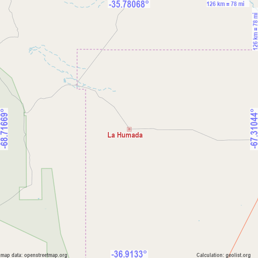
La Humada GPS coordinates[2]
36° 20' 56.58" South, 68° 0' 48.816" West
| Map corner | latitude | longitude |
|---|---|---|
| Upper-left | -35.78068°, | -68.71669° |
| Center: | -36.34905°, | -68.01356° |
| Lower-right: | -36.9133°, | -67.31044° |
| Map W x H: | 125.9×125.9 km | = 78.2×78.2mi |
| max Lat: | -21.94467° ⇑82.8% North |
| La Humada: | -36.34905° |
| min Lat: | ⇓17.2% South -54.81084° |
| min Long | La Humada | max Long |
| -72.88605° | -68.01356° | -53.64581° |
| W 10.5%⇐ | ⇒89.5% E |
Elevation
Elevation of La Humada is 826 m = 2710 ft, and this is 476.7 m = 1564 ft above average elevation for this country.
| Max E: |
4040 m = 13255 ft | 11% |
| La Humada | 826 m 2710 ft | |
| Avg. | 349.3 m = 1146 ft | |
Min E: |
-2 m = -7 ft | 89% |
See also: Argentina elevation on elevation.city.
Geographical zone
La Humada is located in South temperate zone (between Tropic of Capricorn and the Antarctic Circle). Distance of this Southern Tropic circle is 1435.7 km =892.1 mi to North.| Distance of | km | miles | from La Humada |
|---|---|---|---|
| Equator | 4041.6 | 2511.3 | to North |
| Tropic Capricorn | 1435.7 | 892.1 | to North |
| Antarctic Circle | 3359.5 | 2087.5 | to South |
| South Pole | 5965.4 | 3706.7 | to South |


Nearby cities:
15 places around La Humada: (largest is in red/bold)
• Algarrobo del Águila
78 km =48.5 mi,  94°
94°
• Barrancas
177.8 km =110.5 mi,  252°
252°
• Buta Ranquil
183.6 km =114.1 mi,  244°
244°
• Catriel
171.2 km =106.4 mi,  173°
173°
• Chos Malal
231.1 km =143.6 mi, 240°
• General Alvear
155.3 km =96.5 mi,  10°
10°
• Limay Mahuida
149.5 km =92.9 mi,  127°
127°
• Malargüe
171.6 km =106.6 mi,  304°
304°
• Rincón de Los Sauces
142.3 km =88.4 mi,  214°
214°
• San Rafael
194.6 km =120.9 mi,  351°
351°
• Santa Isabel
97 km =60.3 mi,  81°
81°
• Telén
224.5 km =139.5 mi, 87°
• Unión
229.1 km =142.4 mi,  54°
54°
• Veinticinco de Mayo
160.6 km =99.8 mi, 170°
• Victorica
231.5 km =143.8 mi, 86°
Sources, notices
• [Note1] Compared only with cities in Argentina existing in our database
• [Src1] Map data: © OpenStreetMap contributors (CC-BY-SA)
• [Src2] Other city data from geonames.org with taken over terms of usage.
• [Src3] Geographical zone / Annual Mean Temperature by Robert A. Rohde @ Wikipedia
